
Overview of traffic planning of Thanh Hoa commune
According to the land use planning adjustment map for the period 2021 - 2030 of Thanh Hoa district, Long An province, Thanh Hoa commune will have a number of new roads opened to complete the traffic network and promote socio-economic development. Of which, there are two notable routes with the role of connecting important roads and residential areas.
Thanh Hoa commune is geographically adjacent to Thanh Phuoc, Tan Tay, Tan Phuoc 1, Tan Phuoc 2 and Tan Thanh communes, creating favorable conditions for regional connectivity through new infrastructure projects.

Details of 2 routes that will open in the future
Below are details of the two routes shown in the plan, based on the adjusted map of Thanh Hoa district.
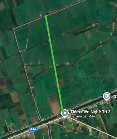
1. The route is perpendicular to Duong Van Duong canal
This route is expected to be approximately 2.2 km long. According to the planning diagram, the route is almost perpendicular to Duong Van Duong canal, running through the area near Pho Huong pagoda. When formed, this route is expected to create a new traffic axis, supporting travel and transport of goods for people in the area.

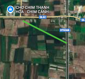
2. Route connecting Provincial Road 836B and National Highway 62
The second route is shorter, about 750 m in length. The highlight of this route is the ability to directly connect two important roads. One end of the route will intersect with Provincial Road 836B, while the other end will head towards National Highway 62. The opening of this route will help shorten the travel distance and strengthen the connection between the provincial road network and the national highway through the commune.
Note: The diagrams in the article are drawn relatively based on the Land Use Planning Adjustment Map for the period 2021 - 2030 of Thanh Hoa district, Long An province. Planning information may change in the future according to decisions of competent authorities.
Source: https://baolamdong.vn/quy-hoach-thanh-hoa-long-an-lo-trinh-2-tuyen-duong-moi-408571.html


![[Photo] 60th Anniversary of the Founding of the Vietnam Association of Photographic Artists](/_next/image?url=https%3A%2F%2Fvphoto.vietnam.vn%2Fthumb%2F1200x675%2Fvietnam%2Fresource%2FIMAGE%2F2025%2F12%2F05%2F1764935864512_a1-bnd-0841-9740-jpg.webp&w=3840&q=75)
![[Photo] National Assembly Chairman Tran Thanh Man attends the VinFuture 2025 Award Ceremony](/_next/image?url=https%3A%2F%2Fvphoto.vietnam.vn%2Fthumb%2F1200x675%2Fvietnam%2Fresource%2FIMAGE%2F2025%2F12%2F05%2F1764951162416_2628509768338816493-6995-jpg.webp&w=3840&q=75)


Comment (0)