
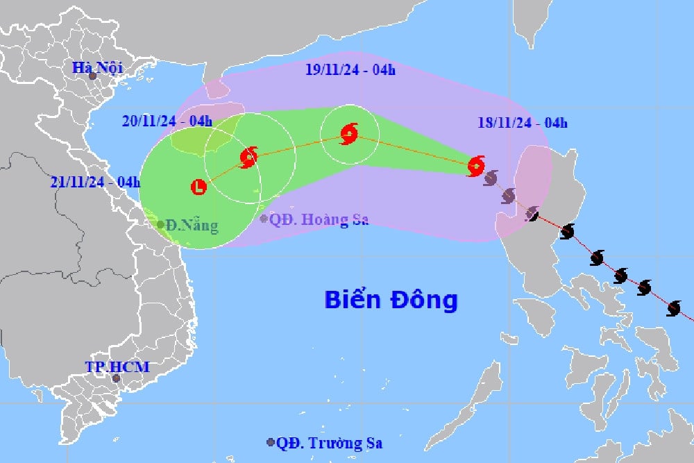
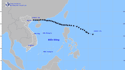
Storm No. 9 Man-yi is at level 9, gusting to level 11, 350km from Hoang Sa archipelago and is weakening. It is forecast that by tomorrow (November 20), the storm will become a low pressure area in the sea off the Central Central region.
In the next 24-36 hours, storm No. 9 will move West Southwest and continue to weaken.
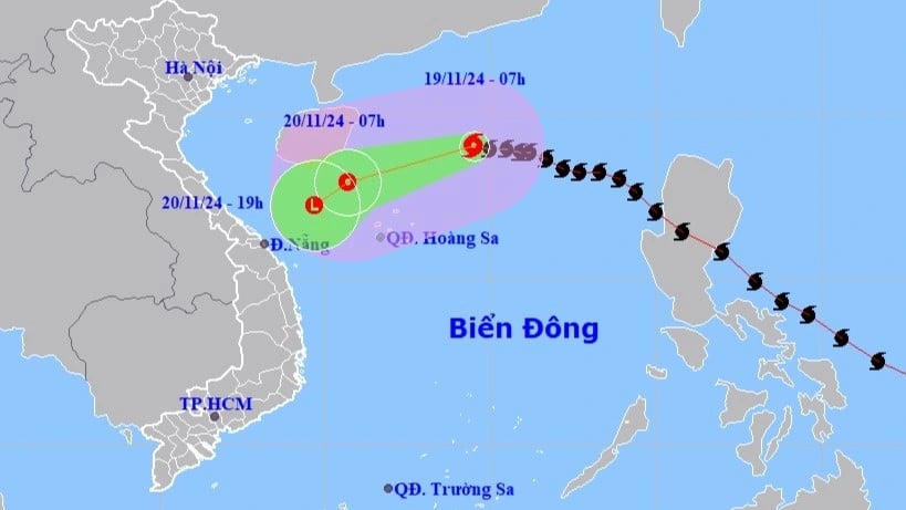
Specifically, at 7am tomorrow morning (November 20), the storm's eye will be in the west of the North East Sea; about 190km northwest of Hoang Sa archipelago, moving at 15-20km/h; the intensity will decrease to level 7, gusting to level 9.
In the next 12 hours, storm No. 9 will move to the sea off the Central Central Coast at a speed of about 10km/h, and gradually weaken into a tropical depression, then a low pressure area.
Due to the impact of the storm, the North East Sea area (including the sea area north of Hoang Sa archipelago) has strong winds of level 6-7, the area near the storm's eye has winds of level 8-9, gusts of level 11, waves 3-5m high, the area near the storm's eye is 5-7m; the sea is very rough.
Vessels operating in the above mentioned danger zones are susceptible to strong winds and large waves.
In addition, in the past 6 hours, the provinces from Thua Thien Hue to Binh Dinh have had moderate to heavy rain. Soil moisture models show that some areas in the above provinces are nearly saturated (over 85%) or have reached saturation. There is a very high risk of flash floods and landslides.
Storm No. 9 formed, encountered cold air weakening in the Central Central Sea

La Nina develops unexpectedly, cold air is strongest in the second half of December

Hanoi weather for the next 3 days: Cold air flows in, lowest temperature drops to 18 degrees
Source: https://vietnamnet.vn/tin-moi-nhat-ve-bao-so-9-cuong-do-cap-11-cach-quan-dao-hoang-sa-350km-2343352.html
![[Photo] National Assembly Chairman Tran Thanh Man attends the VinFuture 2025 Award Ceremony](/_next/image?url=https%3A%2F%2Fvphoto.vietnam.vn%2Fthumb%2F1200x675%2Fvietnam%2Fresource%2FIMAGE%2F2025%2F12%2F05%2F1764951162416_2628509768338816493-6995-jpg.webp&w=3840&q=75)

![[Photo] 60th Anniversary of the Founding of the Vietnam Association of Photographic Artists](/_next/image?url=https%3A%2F%2Fvphoto.vietnam.vn%2Fthumb%2F1200x675%2Fvietnam%2Fresource%2FIMAGE%2F2025%2F12%2F05%2F1764935864512_a1-bnd-0841-9740-jpg.webp&w=3840&q=75)


Comment (0)