
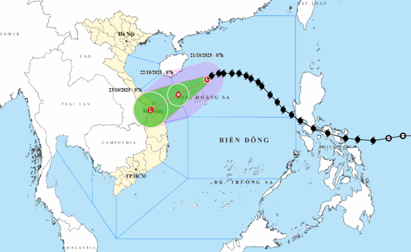
Forecast at 7:00 a.m. on October 22, the eye of the storm is located in the sea west of Hoang Sa special zone, about 220km east-northeast of Da Nang city.
The storm changed direction and moved west-southwest at a speed of about 10-15km/hour into the sea from south of Quang Tri to Quang Ngai with the strongest wind at level 9, gusting to level 11.
At 7:00 a.m. on October 23, the center of the storm was at about 15.6 degrees north latitude, 107.9 degrees east longitude, right on the mainland from Da Nang city to Quang Ngai, with the intensity likely to gradually weaken into a tropical depression, then a low pressure area.
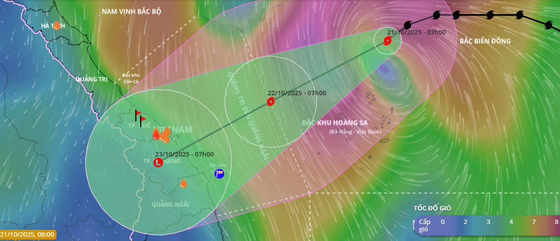
Due to the storm's influence, the North East Sea (including Hoang Sa special zone) has strong winds of level 7-8; the area near the storm's eye has strong winds of level 9-10, gusting to level 12; waves 3-5m high, the area near the storm's eye has waves of 5-7m high, and very rough seas.
The sea area from the south of Quang Tri to Quang Ngai (including Ly Son special zone) has strong winds of level 6, increasing to level 7 from the morning of October 22, the area near the storm center has level 8, gusts of level 10, waves 3-5m high, rough seas.
All ships and boats operating in dangerous areas at sea are susceptible to the effects of storms, whirlwinds, strong winds and large waves.
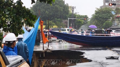
On the mainland of Da Nang city, due to the influence of storm circulation and cold air combined with easterly wind disturbances and terrain effects, from the afternoon of October 22 to 27, Da Nang is likely to experience a widespread heavy rain, lasting for many days, with some areas having very heavy rain with total rainfall of 400-700mm, in some places over 900mm.
High risk of flash floods and landslides in mountainous areas, flooding in low-lying and urban areas.
Localities need to prepare response plans for flood scenarios on rivers in Da Nang city that could reach alert level 2 to alert level 3, with some rivers above alert level 3.
Source: https://baodanang.vn/tu-chieu-22-10-da-nang-bat-dau-dot-mua-lon-keo-dai-3306882.html

![[Photo] National Assembly Chairman Tran Thanh Man attends the VinFuture 2025 Award Ceremony](/_next/image?url=https%3A%2F%2Fvphoto.vietnam.vn%2Fthumb%2F1200x675%2Fvietnam%2Fresource%2FIMAGE%2F2025%2F12%2F05%2F1764951162416_2628509768338816493-6995-jpg.webp&w=3840&q=75)


![[Photo] 60th Anniversary of the Founding of the Vietnam Association of Photographic Artists](/_next/image?url=https%3A%2F%2Fvphoto.vietnam.vn%2Fthumb%2F1200x675%2Fvietnam%2Fresource%2FIMAGE%2F2025%2F12%2F05%2F1764935864512_a1-bnd-0841-9740-jpg.webp&w=3840&q=75)


Comment (0)