
Cold air affects the weather on land and at sea
The National Center for Hydro-Meteorological Forecasting said that cold air has affected and caused rain in many places in the Northeast, North Central and some places in the Northwest. At Bach Long Vy station, there is strong Northeast wind at level 6, sometimes level 7, gusting to level 8.
It is forecasted that on the night of November 3 and the day of November 4, cold air will continue to affect other places in the Northwest region and some places in the Central Central region. On land, strong northeast winds will be at level 2-3, and coastal areas at level 3-4.
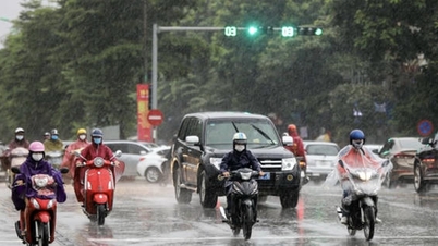
Due to the influence of the cold air strengthening, from the evening of November 3 to 5, the North, Thanh Hoa and the North of Nghe An will have scattered rain. The lowest temperature in this cold air in the North and North Central regions is generally from 16-19 degrees Celsius, in mountainous areas it is below 15 degrees Celsius. Also due to the influence of the cold air strengthening combined with disturbances in the upper East wind zone, the area from Ha Tinh to Hue city will continue to have widespread heavy rain.
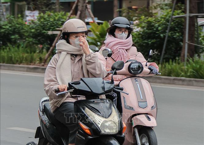
Hanoi area from the evening of November 3-4 will have rain, the weather will continue to be cold. The lowest temperature in this cold air mass is commonly 17-19 degrees Celsius.
Cold weather can affect livestock and poultry and the growth and development of crops.
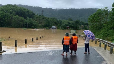
Heavy rain can cause flooding in low-lying areas; flash floods in small rivers and streams, landslides on steep slopes; heavy rain in a short period of time can cause flooding in urban areas and industrial zones.
At sea, in the Gulf of Tonkin, the Northeast wind is strong at level 6, sometimes at night it is level 7, gusting to level 8, rough seas, waves 2-3.5m high; in the North East Sea, the Northeast wind is strong at level 6-7, gusting to level 8-9, rough seas, waves 3-5m high. Strong winds and gusts, big waves at sea can affect the operations of ships and other activities.
Heavy rain from Ha Tinh to Hue city
The National Center for Hydro-Meteorological Forecasting predicts that from the evening of November 3 to the night of November 4, the area from Ha Tinh to Quang Tri will have heavy to very heavy rain with common rainfall of 150-250mm, locally over 400mm. Hue city from the evening to the end of the night of November 3 will have moderate to heavy rain with common rainfall of 40-70mm, locally over 100mm. Warning of the risk of heavy rain over 150mm/3 hours.
In addition, in the afternoon and evening of November 3, in the Central Highlands and the South, there will be scattered showers and thunderstorms with rainfall of 10-30mm, with some places having heavy rain over 60mm. Warning of the risk of heavy rain over 60mm/3 hours.
Warning: From November 5 to the morning of November 6, heavy rain in the above area tends to decrease.
Level 1 natural disaster risk due to heavy rain, tornado, lightning, hail.
Flood warning on rivers in the Central region
The National Center for Hydro-Meteorological Forecasting warned that from about 4:30 p.m. to 9:30 p.m. on November 3, flood levels on the Thu Bon River at Cau Lau station are likely to peak at level 3, 0.6 - 0.7 meters above alert level 3.
In the next 12 hours, floods on Huong River and Bo River will continue to decrease and be above alert level 3; Vu Gia - Thu Bon River will decrease and be below alert level 3 to alert level 3.
In the next 12 - 24 hours, floods on Huong River and Bo River will continue to decrease and be below alert level 3; Vu Gia - Thu Bon River will continue to decrease and be above alert level 2.
In the next 24 hours, the flood on Ngan Sau River will fluctuate at alert level 1 to above alert level 1. From now until November 5, the flood on rivers in Ha Tinh, Quang Tri, and Quang Ngai is likely to rise again. During this flood, the peak water level on Ngan Sau and Ngan Pho rivers (Ha Tinh), Gianh River, Kien Giang River, and Thach Han River (Quang Tri) will reach alert level 2 - alert level 3, with some rivers above alert level 3.
Warning of flood risk in low-lying areas along rivers, urban areas, and densely populated areas in provinces/cities from Ha Tinh to Da Nang. High risk of flash floods on rivers and streams and landslides on slopes in provinces/cities from Ha Tinh to Da Nang. Warning of level 3 flood risk.
"The forecast and warning information is calculated based on the expected operating level of upstream reservoirs. The hydrometeorological agency will update the bulletins when there are changes in the discharge flow of the reservoirs," emphasized Hoang Van Dai, Deputy Director of the National Center for Hydrometeorological Forecasting.
Floods on rivers and inundation in low-lying areas affect activities such as water transport, aquaculture, agricultural production, people's lives and socio-economic activities.
Risk of flooding in low-lying coastal areas in the Southeast region
According to information from the National Center for Hydro-Meteorological Forecasting, from the evening of November 3 to November 4, the coastal areas of provinces/cities from Ho Chi Minh City to Ca Mau at Vung Tau station will have a high water level of 4 - 4.1m, with peak tides occurring from 11am - 1am and from 1pm - 4pm. Areas at risk of flooding due to high tides are low-lying areas and areas outside the dike.
It is forecasted that from November 4 to 5, the highest water level in the eastern coastal area of the South will tend to rise slowly, the highest tide of the day at Vung Tau station is likely to reach 4.1 - 4.2m. From November 6 to 11, the tide level in the eastern coastal area of the South will continue to rise slowly. The highest tide of the day at Vung Tau station may reach 4.2 - 4.3m.
"This is a high tide period, the eastern coastal area of the South needs to pay attention to prevent high risks of flooding and dike overflow in low-lying coastal areas, riverside areas, and outside the dike, affecting traffic, agricultural production, aquaculture, water pollution and people's lives in the eastern coastal area of the South", Head of the Oceanographic Forecasting Department Bui Manh Ha noted.
Weather in different regions on the night of November 3 and November 4
In the Northwest, there will be rain at night, scattered rain during the day, cold weather, some places will be very cold; especially in Dien Bien - Lai Chau, it will be cold. Light wind. Lowest temperature 17-20 degrees Celsius, some places below 16 degrees Celsius. Highest temperature 19-22 degrees Celsius, especially in Lai Chau - Dien Bien 22-25 degrees Celsius.
In the Northeast, there will be rain at night, scattered rain during the day, cold weather, some mountainous areas will be very cold. Northeast wind level 2-3, coastal areas level 3-4. Lowest temperature 16-19 degrees Celsius, some mountainous areas below 15 degrees Celsius. Highest temperature 19-22 degrees Celsius, some places above 22 degrees Celsius.
Hanoi city has rain, cold weather. Northeast wind level 2-3. Lowest temperature 17-19 degrees Celsius. Highest temperature 19-21 degrees Celsius.
Provinces and cities from Thanh Hoa - Hue, the North has rain; the South (Ha Tinh - Hue city) has moderate rain, heavy rain, locally very heavy rain and thunderstorms. North to Northwest wind level 2-3, coastal areas level 3-4. Cold weather, cold in the North. Lowest temperature 18-21 degrees Celsius. Highest temperature in the North 20-23 degrees Celsius, in the South 24-26 degrees Celsius.
The South Central Coast has scattered showers and thunderstorms at night; scattered showers and thunderstorms during the day, with some places having heavy rain; thunderstorms have the possibility of tornadoes, lightning, and strong gusts of wind. In the North, the wind is from the East to the Northeast at level 2-3; in the South, the wind is from the Southwest at level 2-3. The lowest temperature is 22-25 degrees Celsius. The highest temperature is 29-32 degrees Celsius.
The Central Highlands has scattered showers and thunderstorms; in the afternoon and evening there will be scattered showers and thunderstorms, locally heavy rain, with the possibility of tornadoes, lightning, hail and strong gusts of wind. The lowest temperature is 18-21 degrees Celsius. The highest temperature is 27-30 degrees Celsius.
The South has scattered showers and thunderstorms; in the afternoon and evening there will be scattered showers and thunderstorms, locally heavy rain, with the possibility of tornadoes, lightning, hail and strong gusts of wind. Lowest temperature 23-26 degrees Celsius. Highest temperature 30-33 degrees Celsius.
Ho Chi Minh City has scattered showers and thunderstorms; in the afternoon and evening there will be scattered showers and thunderstorms, locally heavy rain, with the possibility of tornadoes, lightning, hail and strong gusts of wind. Lowest temperature 24-26 degrees Celsius. Highest temperature 30-32 degrees Celsius.
Source: https://baotintuc.vn/van-de-quan-tam/tu-dem-3-411-vung-nui-cao-bac-bo-co-noi-ret-dam-20251103170958523.htm


![[Photo] The road connecting Dong Nai with Ho Chi Minh City is still unfinished after 5 years of construction.](https://vphoto.vietnam.vn/thumb/1200x675/vietnam/resource/IMAGE/2025/11/04/1762241675985_ndo_br_dji-20251104104418-0635-d-resize-1295-jpg.webp)
![[Photo] Ca Mau "struggling" to cope with the highest tide of the year, forecast to exceed alert level 3](https://vphoto.vietnam.vn/thumb/1200x675/vietnam/resource/IMAGE/2025/11/04/1762235371445_ndo_br_trieu-cuong-2-6486-jpg.webp)
![[Photo] Panorama of the Patriotic Emulation Congress of Nhan Dan Newspaper for the period 2025-2030](https://vphoto.vietnam.vn/thumb/1200x675/vietnam/resource/IMAGE/2025/11/04/1762252775462_ndo_br_dhthiduayeuncbaond-6125-jpg.webp)
![[Photo] Ho Chi Minh City Youth Take Action for a Cleaner Environment](https://vphoto.vietnam.vn/thumb/1200x675/vietnam/resource/IMAGE/2025/11/04/1762233574890_550816358-1108586934787014-6430522970717297480-n-1-jpg.webp)


Comment (0)