
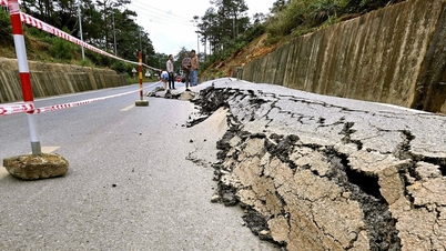
On February 7th (the 28th day of the 12th lunar month), the Institute of Geophysics recorded five consecutive earthquakes in Kon Plông District, Kon Tum Province.
Accordingly, the first earthquake, with a magnitude of 3.7 on the Richter scale, occurred at 10:49 AM at coordinates 14.829 degrees North latitude and 108.273 degrees East longitude (in Kon Plong District). The most recent earthquake was recorded at 11:40 AM on the same day with a magnitude of 2.8 on the Richter scale, occurring at coordinates 14.847 degrees North latitude and 108.280 degrees East longitude.

A 4.0 magnitude earthquake was recorded in Kon Tum on February 7th.
INSTITUTE OF GEOPHYSICS
Five consecutive earthquakes struck Kon Tum on the 28th day of the Lunar New Year.
All five earthquakes occurred within less than an hour. The strongest earthquake measured 4.0 on the Richter scale. All five earthquakes were classified as level 0 natural disaster risk. No casualties or property damage have been reported so far.
According to the Kon Tum Provincial Department of Industry and Trade, experts have determined that the earthquake in Kon Plông District was an induced earthquake. This was caused by the water storage and release activities of hydroelectric reservoirs. To date, Kon Tum province has installed eight earthquake monitoring stations at the Thượng Kon Tum and Đăk Đrinh hydroelectric power plants (Kon Plông District).
Source link


Comment (0)