
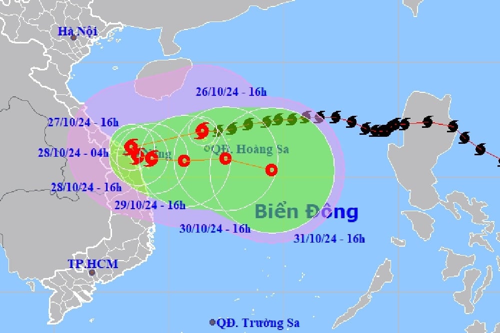
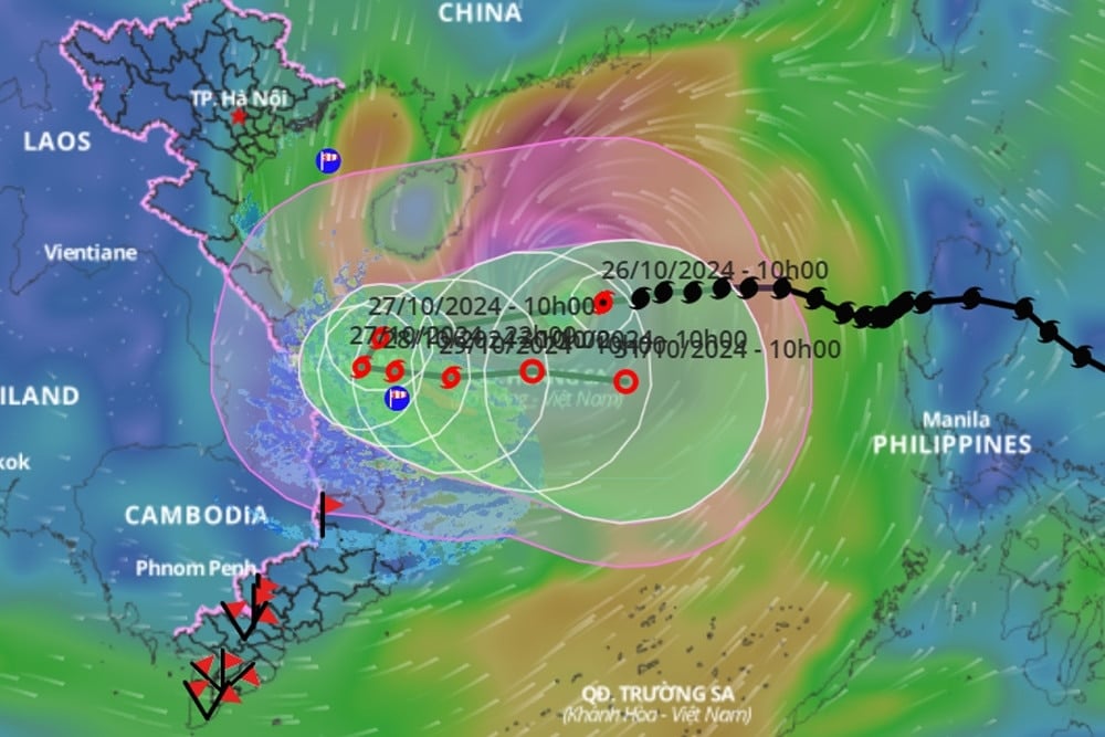
According to the National Center for Hydro-Meteorological Forecasting, as of 7 PM tonight (October 26th), the center of Typhoon No. 6 (Typhoon Tra Mi) is located in the sea northwest of the Hoang Sa archipelago, approximately 290km east-northeast of Da Nang . The strongest winds near the center of the typhoon are at level 11 (103-117 km/h), with gusts up to level 14. It is moving westward at a speed of about 20 km/h.
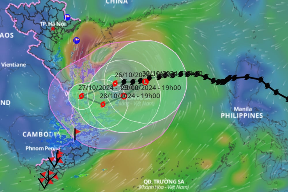
Over the next 24 hours, the storm will change direction, moving west-southwest at a speed of approximately 15 km/h. By 7 PM tomorrow (October 27th), the storm's center will be located over the provinces of Quang Tri and Quang Nam, with wind speeds of level 8, gusting to level 11.
Approximately 24 hours later, Typhoon No. 6 changed direction again, moving south-southeast before turning east, slowing to about 5 km/h and heading back out to sea. By 7 PM on October 28th, the typhoon's center was located in the sea off the coast of Central Vietnam with an intensity of level 7, gusts of level 10, and weakened into a tropical depression.
By 7 PM on October 29th, the tropical depression was moving eastward at a speed of 10 km/h over the area south of the Hoang Sa archipelago, with wind speeds of level 6, gusting to level 8.
Over the next 72 to 96 hours, the tropical depression moved mainly eastward at a speed of about 10 km per hour and gradually weakened into a low-pressure area.
Due to the influence of the remnants of typhoon No. 6, the western sea area of the North East Sea will experience strong winds of force 8-9, reaching force 10-11 (89-117 km/h) near the center of the typhoon, with gusts up to force 14; sea waves will be 4-6 meters high, and 6-8 meters near the center of the typhoon; the sea will be extremely rough.
The sea areas off the provinces from Quang Binh to Quang Ngai (including Con Co Island, Cu Lao Cham Island, and Ly Son Island) will experience strong winds of force 6-7, later increasing to force 8, reaching force 9-10 near the storm's center, with gusts up to force 12; sea waves will be 3-5m high, and 4-6m near the storm's center; the sea will be very rough.
At the same time, the meteorological agency warned that from tomorrow morning (October 27), coastal areas of provinces from Quang Binh to Quang Nam are likely to experience storm surge of 0.4-0.6m.
Ships and boats operating in the aforementioned hazardous areas (especially in the Hoang Sa archipelago), and the coastal waters from Quang Binh to Quang Ngai, are all susceptible to the effects of thunderstorms, tornadoes, strong winds, and large waves.
There is a high risk of erosion of dikes and seawalls along the coast of provinces from Quang Tri to Quang Nam due to the impact of large waves and storm surges.
On land, from tomorrow morning, Quang Binh to Quang Ngai will experience increasingly strong winds, reaching levels 6-7, gusting to levels 8-9; areas near the storm's center will experience winds of level 8, gusting to level 11.
Due to the influence of the circulation of typhoon No. 6, from tonight until the night of October 28th, the area from Quang Binh to Quang Ngai will experience heavy to very heavy rain with total rainfall generally ranging from 300-500mm, and in some localized areas exceeding 700mm. A warning is issued for the risk of localized heavy rainfall (>100mm/3h). The areas of Ha Tinh, Binh Dinh, and the Northern Central Highlands will experience heavy rain, with localized areas experiencing very heavy rain, with total rainfall generally ranging from 100-200mm, and in some places exceeding 300mm.
The development of Typhoon No. 6 remains very complex and subject to change; people should pay attention to updates in subsequent typhoon bulletins.
Typhoon No. 6 is approaching the central coast, bringing very heavy and prolonged rainfall.
From early morning and tomorrow (October 27th), Typhoon No. 6 (Typhoon Tra Mi) will reach the coastal area from Quang Tri to Quang Nam with an intensity of level 8-9. Heavy and prolonged rainfall during the typhoon's circulation may cause flooding and flash floods.
Typhoon Tra Mi (Typhoon No. 6) will enter the central coastal region of Vietnam, bringing heavy rain to 6 provinces starting tonight.
Typhoon No. 6 (Typhoon Tra Mi) is about to reach its peak intensity with gusts up to level 15, approximately 500km from Da Nang. It is forecast that by the morning of October 27th, the typhoon's center will be over the sea off the coast of Central Vietnam. From this evening onwards, the Quang Binh – Quang Ngai area will experience heavy rain.
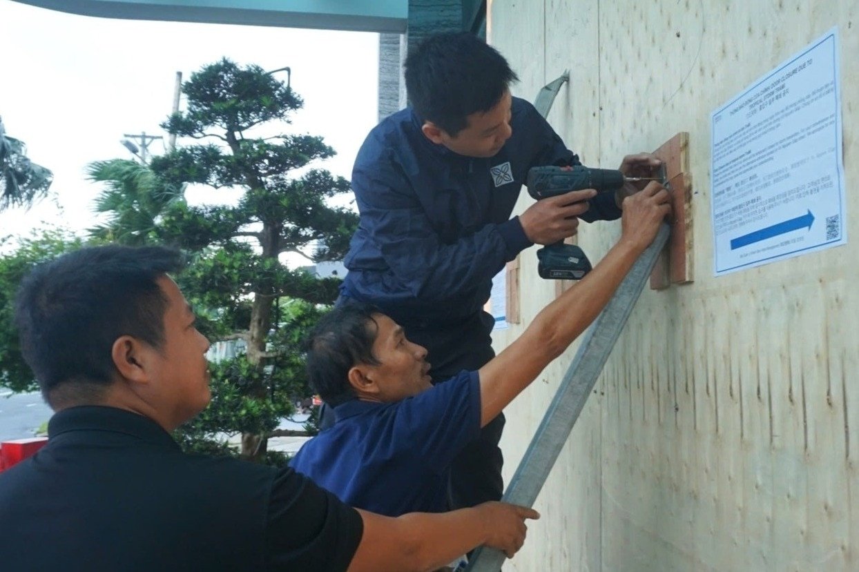
Responding to Typhoon Tra Mi: Da Nang requests residents to limit going out from 10 AM tomorrow.
The Chairman of the Da Nang City People's Committee has requested residents to limit leaving their homes starting at 10:00 AM on October 27th to ensure safety when the storm makes landfall.


![[Photo] Prime Minister Pham Minh Chinh holds a phone call with the CEO of Russia's Rosatom Corporation.](/_next/image?url=https%3A%2F%2Fvphoto.vietnam.vn%2Fthumb%2F1200x675%2Fvietnam%2Fresource%2FIMAGE%2F2025%2F12%2F11%2F1765464552365_dsc-5295-jpg.webp&w=3840&q=75)
![[Photo] Closing Ceremony of the 10th Session of the 15th National Assembly](/_next/image?url=https%3A%2F%2Fvphoto.vietnam.vn%2Fthumb%2F1200x675%2Fvietnam%2Fresource%2FIMAGE%2F2025%2F12%2F11%2F1765448959967_image-1437-jpg.webp&w=3840&q=75)


![[OFFICIAL] MISA GROUP ANNOUNCES ITS PIONEERING BRAND POSITIONING IN BUILDING AGENTIC AI FOR BUSINESSES, HOUSEHOLDS, AND THE GOVERNMENT](https://vphoto.vietnam.vn/thumb/402x226/vietnam/resource/IMAGE/2025/12/11/1765444754256_agentic-ai_postfb-scaled.png)


Comment (0)