
“Bottleneck”
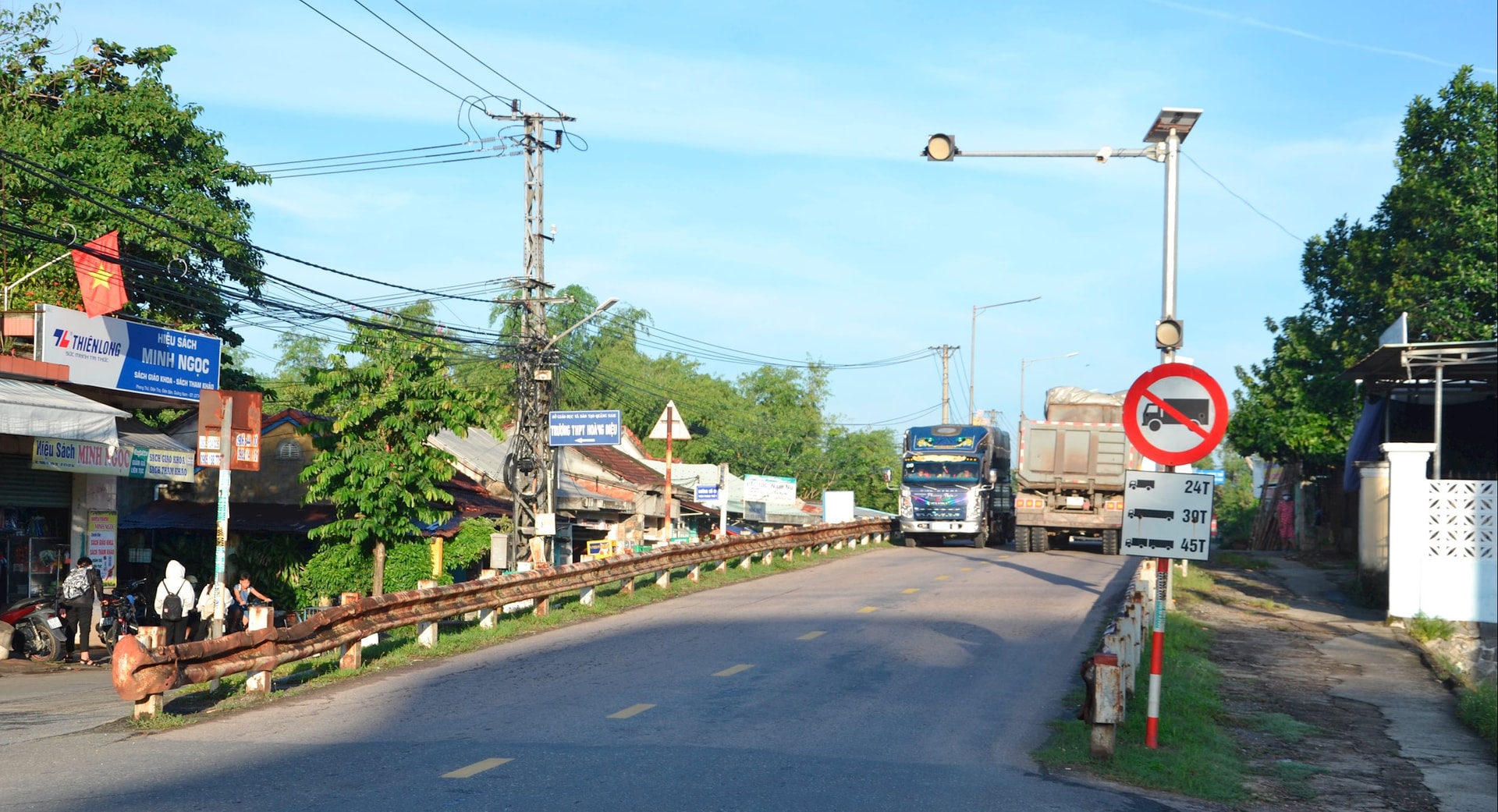
At around 6:30 a.m., Ms. TH (residing in Phong Thu 1 village, Dien Ban Tay commune) was driving her relatives on a motorbike, wanting to go from the right side to the left side of DT609 road, east of Phong Thu bridge, but she watched for a long time before moving to the other side. "The traffic is very heavy at this time, partly because it is the time when students turn into schools on the left side of Phong Thu bridge, and partly because there are many vehicles crossing the bridge, including many passenger cars and heavy trucks," she said.
Also having difficulty traveling on route DT609 like Ms. H., many local people shared that the road surface on both sides of the road leading to Phong Thu bridge was renovated and expanded many years ago, part of the project to upgrade and expand route DT609.
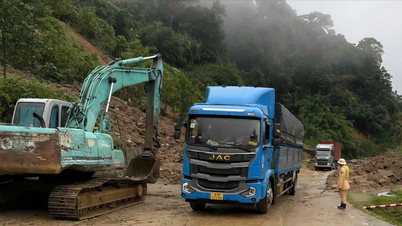
Phong Thu Bridge is a separate project, approved for investment in December 2022, with a total investment of 125 billion VND from the budget of Quang Nam province (old). However, the project has not yet set a start date due to budget difficulties. Therefore, Phong Thu Bridge is still a "bottleneck" so 2 large trucks cannot travel in opposite directions.
.jpg)
Every day, thousands of cars, especially heavy trucks, pass Phong Thu bridge, many of which enter and exit the Da Nang - Quang Ngai expressway. The bridge is also a place where people go to Phong Thu market to trade, workers go to the eastern region to work, and students go to school to study. On the contrary, the old bridge is narrow, and traffic jams and collisions often occur during rush hour. In 2024, during the time of traffic diversion due to the ban on cars crossing the new Cau Lau bridge on National Highway 1, the traffic volume of heavy trucks crossing Phong Thu bridge increased dramatically, causing damage to the bridge. Therefore, in December 2024, the authorities banned semi-trailers from crossing the bridge.
Mr. Tran Ngoc Thanh, Deputy Director of the Department of Construction, said that the DT609 route has a total length of more than 74km; the starting point intersects with the old National Highway 1 in Dien Ban Ward, the end point connects with Ho Chi Minh Road in Ben Hien Commune. Up to now, the route has a section of km20+960-km24+750 that has not been upgraded or expanded. Like Phong Thu Bridge, the Loc My Bridge, Ba Khe 1 (in Ha Nha Commune), Ba Khe 2 (border between Ha Nha Commune and Thuong Duc Commune), Ba Khe 3 (in Thuong Duc Commune) have never been invested in for new construction.
Need to build new soon
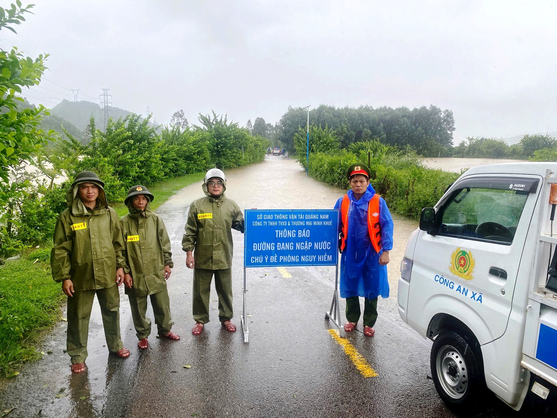
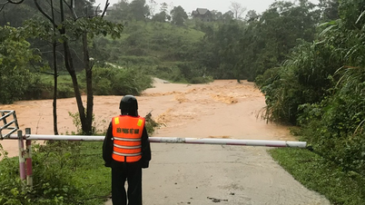
The rain continued due to the impact of storm No. 10. On September 28, the water level of Vu Gia River rose to level 2 before crossing Ba Khe 2 Bridge, causing traffic congestion. Teacher Nguyen Ba Ngan, Principal of Chu Van An High School (located in Ha Nha Commune), shared that because September 28 was Sunday, students had no school, but he was still at school to work.
“On a weekday, I ran to the Ba Khe 2 bridge area to check the flood situation so that I could inform students to take the initiative to stay home from school, so that teachers who live far away would not have to go to school and then return empty-handed,” said Mr. Ngan.
.jpg)
Mr. Ngan explained that the Ba Khe 2 and Ba Khe 3 bridges are at the lowest point of the DT609 route. The Vu Gia River had not yet reached the 2nd alarm level when it had already crossed, cutting off traffic. That is why, with the heavy rain that continued for a long time, Mr. Ngan went up there early in the morning to check the situation, because he was worried that students from Thuong Duc commune would encounter floodwaters. There was a case where students were finishing school and going home near Ba Khe 3 bridge when they encountered floodwaters and had to turn back to school. However, when they reached Ba Khe 2 bridge, they also encountered a similar situation, and the school had to call the authorities for help.
In reality, the three Ba Khe bridges have such narrow cross-sections that two cars cannot pass through at the same time. Ba Khe 2 bridge only has wheel guards, no railings; the railings of Ba Khe 3 bridge are skewed and cracked in many places.
A close look shows that Ba Khe 2 and Ba Khe 3 bridges are no different from box culverts, not the right size for a bridge located on the main road leading to the national historical site of Thuong Duc Victory Monument, or Dong Giang Heaven Gate Eco-tourism Area with an investment capital of thousands of billions of dong. Not to mention, the road section through Ba Khe 2 bridge is curved, so fast-moving vehicles can easily hit the wheel guard and fall off the bridge.
Through contacts with People's Council delegates at all levels and National Assembly delegates, voters of communes through which Highway 609 passes have repeatedly requested competent authorities to promptly allocate capital to build bridges on the route to remove the long-standing "bottleneck", resolve the current situation of traffic insecurity, and serve search and rescue.
At the same time, effectively exploit this vital horizontal axis in the traffic system connecting with Da Nang - Quang Ngai Expressway, DT609B, Giao Thuy Bridge, An Binh Bridge, National Highway 14B, Ho Chi Minh Road.
DT609 has a total length of more than 74km. The starting point intersects with National Highway 1 (old) in Dien Ban Ward, the end point connects to Ho Chi Minh Road in Ben Hien Commune. The route passes through Dien Ban and An Thang Wards; Dien Ban Tay, Dai Loc, Ha Nha, Thuong Duc and Ben Hien Communes. DT609 is a vital horizontal axis, connecting seamlessly with the old National Highway 1, Da Nang - Quang Ngai Expressway, DT605 and Van Ly Bridge, DT609B and Giao Thuy Bridge, An Binh Bridge and National Highway 14B, Ho Chi Minh Road.
Source: https://baodanang.vn/can-xay-dung-mo-rong-cau-tren-tuyen-dt609-3306847.html

![[Photo] 60th Anniversary of the Founding of the Vietnam Association of Photographic Artists](/_next/image?url=https%3A%2F%2Fvphoto.vietnam.vn%2Fthumb%2F1200x675%2Fvietnam%2Fresource%2FIMAGE%2F2025%2F12%2F05%2F1764935864512_a1-bnd-0841-9740-jpg.webp&w=3840&q=75)
![[Photo] National Assembly Chairman Tran Thanh Man attends the VinFuture 2025 Award Ceremony](/_next/image?url=https%3A%2F%2Fvphoto.vietnam.vn%2Fthumb%2F1200x675%2Fvietnam%2Fresource%2FIMAGE%2F2025%2F12%2F05%2F1764951162416_2628509768338816493-6995-jpg.webp&w=3840&q=75)


Comment (0)