
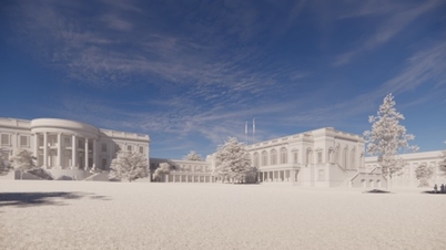
The adjustments are made on the principle of maintaining the original location, boundaries, land use functions, and architectural planning indicators such as plot area, building area, density, land use coefficient, building height, and total floor area.
These elements are consistent with the approved overall adjustment plan for the detailed planning of the West Lake Urban Center at a scale of 1/500.
The planning ensures synchronous connection and compatibility with the overall social and technical infrastructure of the area; it does not alter the transportation system or the framework technical infrastructure already defined in the overall adjustment plan and the H2-1 zoning plan at a scale of 1/2000. Implementation complies with the National Technical Regulation QCVN 01:2021/BXD, specialized design standards, and relevant regulations.
") |
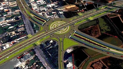
| Perspective view of the West Lake Urban Area. (Photo: Provided) |
According to the revised plan, plot C1-CC3, covering more than 1 hectare, is classified as city-level public land and is planned for the construction of office buildings, commercial services, and a comprehensive cultural complex.
The architectural design requires a modern layout, with a maximum of 35 above-ground floors, harmoniously integrated with neighboring projects. Building boundaries, setbacks, and the height of the base and tower all comply with QCVN 01:2021/BXD. Urban greenery should be selected according to appropriate species, suitable for the natural environment and landscape. The use of LED lighting, solar energy, and artistic lighting at night is encouraged, including lighting for buildings, streets, trees, and gardens.
Regarding technical infrastructure, the plan complies with the overall adjustment scheme. The underground parking area covers more than 2.3 hectares, with charging stations for electric vehicles, a transformer station, and a local wastewater treatment system. The underground space consists of 3 levels, with a total floor area of more than 3.2 hectares. The underground area coincides with the red line boundary and the land plot boundary.
The Hanoi People's Committee has assigned the Hanoi Department of Planning and Architecture to inspect, verify the documents, and update them in the overall dossier. The Xuan Dinh Ward People's Committee will publicly announce the adjusted content and supervise the construction.
The investor - THT Development Co., Ltd. - will carry out the investment and construction procedures in accordance with the plan, ensuring financial obligations and legal procedures regarding land, investment, and construction. Relevant departments and agencies will inspect and guide the implementation in accordance with specialized regulations.
Source: https://thoidai.com.vn/dieu-chinh-khong-gian-kien-truc-trung-tam-khu-do-thi-tay-ho-tay-216156.html


![[Photo] Na Ngoi Border Guard Station distributes 484 gifts to students and households before the cold season.](https://vphoto.vietnam.vn/thumb/402x226/vietnam/resource/IMAGE/2025/12/11/1765453782566_anh-don-bien-phong-na-ngoi-trao-484-suat-qua-cho-hoc-sinh-va-ho-dan-truoc-mua-gia-ret-20251211152111.jpeg)


Comment (0)