
Thousands of boats and ships are being urged to seek shelter.
On October 21st, Da Nang city leaders directed departments, agencies, and communes to proactively implement disaster prevention plans and closely monitor the developments of Typhoon No. 12. The city requested residents to stockpile food and essential supplies for at least three days; and to evacuate people from areas prone to deep flooding and landslides. The Da Nang Department of Education and Training requested schools to decide on school closures based on the actual situation to ensure the safety of students.
. Photo: Xuan Quynh")
The City Military Command requested all units to maintain 100% troop readiness from 5 PM on October 22nd to October 30th, prepared for emergency response. The Permanent Militia Squadron, in coordination with the 3rd Naval Region, guided the safe anchoring of vessels; the 699th Armored Battalion deployed contingency plans in case of adverse situations. The Nguyen Van Troi bridge was raised to allow vessels to seek shelter on the southwest side of the Han River. The City Border Guard also prohibited vessels from going out to sea.
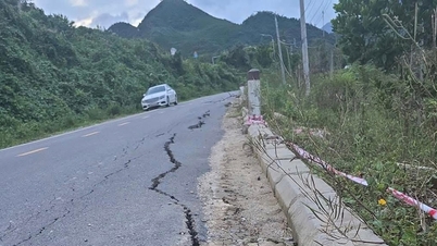
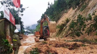
At Tho Quang fishing harbor and dock, more than 3,500 fishing boats from Da Nang, along with hundreds from other central provinces, have anchored to avoid the storm. Fishermen in Son Tra are urgently bringing their boats ashore, utilizing vacant land along Hoang Sa and Le Van Luong roads as shelters. In the highland and border communes of Da Nang City, evacuation efforts are being carried out urgently. Mr. Trinh Minh Hai, Chairman of the People's Committee of Tra Linh commune, said that the commune has relocated 29 households in Kon Pin hamlet (village 2) due to the discovery of a 50m long, 0.5m wide landslide crack, only 35m from people's houses. In Tra Doc commune, heavy rains have created 11 high-risk landslide areas, threatening 541 people. The authorities have organized the evacuation of residents to safe places and deployed forces to critical points to conduct rescue operations in case of isolation.
In Quang Ngai , more than 6,100 fishing boats with 34,300 fishermen have sought safe shelter. Border guards fired flares at four estuaries – Sa Ky, Sa Can, Sa Huynh, and Ly Son – to urge boats to return to shore urgently. Mr. Nguyen Van Huy, Chairman of the People's Committee of Ly Son Special Economic Zone, said that the locality had reinforced houses, relocated fish cages, and mobilized militia and residents to harvest 300 hectares of green onions. The Chairman of the People's Committee of Quang Ngai province, Nguyen Hoang Giang, requested localities to review evacuation plans in high-risk areas such as Rook Met (Dak Plo commune), Xo Thac (Mang But commune), Go Khon (Ba Dinh commune), Tra Linh (Tay Tra Bong commune), Go Oat (Ba Vinh commune), etc.
In Hue, local authorities have prepared plans to evacuate more than 10,000 households with 32,697 people in coastal, lagoon, and low-lying areas to safe locations; and have stockpiled nearly 100 tons of essential food supplies. Fuel companies are ensuring a stable supply in case of prolonged heavy rain and flooding.
High risk of flash floods.
According to the National Center for Meteorological and Hydrological Forecasting, as of late afternoon on October 21st, the center of Typhoon No. 12 is located in the sea north of the Hoang Sa archipelago, approximately 420km east-northeast of Da Nang City. The strongest winds near the center of the typhoon remain at level 9-10 (75-102 km/h), with gusts up to level 12. Since the morning of October 21st, the typhoon has changed direction to the west, then west-southwest, slowing down to 10-15 km/h. By the afternoon of October 22nd, the center of the typhoon will be approximately 125km east-northeast of Da Nang City and will gradually weaken before making landfall in the central region (with the main landfall area being Da Nang - Quang Ngai).
. Photo: Xuan Quynh")
From the afternoon of October 22nd to 23rd, the storm gradually weakened into a tropical depression, then into a low-pressure area, and dissipated as it moved towards Laos. From the afternoon of October 22nd, strong winds will gradually increase to level 6, sometimes level 7, with gusts of level 8-9, over the coastal areas from Quang Tri to Da Nang. Due to the influence of the storm's circulation from noon on October 22nd to October 27th, the area from Ha Tinh to Quang Ngai will experience widespread heavy rain. The total rainfall from Ha Tinh to northern Quang Tri and Quang Ngai will generally be around 200-400mm, with some areas exceeding 500mm; the area from Quang Tri to Da Nang will generally receive 500-700mm, with some areas exceeding 900mm.
According to Mr. Mai Van Khiem, Director of the National Center for Meteorological and Hydrological Forecasting, heavy rain in the Central region is likely to continue until the end of October 2025. There is a high risk of flash floods and landslides in mountainous areas, and flooding in low-lying areas and urban areas. Local authorities should safely operate hydroelectric and irrigation reservoirs before, during, and after the storm, and be prepared to respond to flood scenarios on rivers from Quang Tri to Quang Ngai that could reach or exceed alarm level 3. Particular attention should be paid to the risk of thunderstorms, tornadoes, and strong gusts of wind in areas affected by the storm's circulation, both before and during landfall.
On the evening of October 21st, a cold front affected most areas in Northern Vietnam and some parts of Central Vietnam. In Hanoi, northeasterly winds brought a slight chill in the evening. The National Center for Meteorological and Hydrological Forecasting stated that from October 22nd, a stronger cold front will intensify and move down to Northern Vietnam. Hanoi will become colder at night and in the morning (temperatures in many areas will drop to 17-19 ° C, with some mountainous areas experiencing temperatures below 16 ° C).
Source: https://www.sggp.org.vn/nguoi-dan-mien-trung-tich-tru-luong-thuc-ung-pho-bao-lu-post819242.html


![[Photo] Prime Minister Pham Minh Chinh holds a phone call with the CEO of Russia's Rosatom Corporation.](/_next/image?url=https%3A%2F%2Fvphoto.vietnam.vn%2Fthumb%2F1200x675%2Fvietnam%2Fresource%2FIMAGE%2F2025%2F12%2F11%2F1765464552365_dsc-5295-jpg.webp&w=3840&q=75)


Comment (0)