
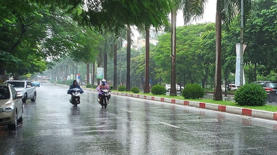
According to the National Center for Hydro-Meteorological Forecasting, from early morning to the night of June 25, in the Northwest region, there will be scattered showers and thunderstorms, locally heavy rain with rainfall from 15-30mm, locally over 80mm.
In the Viet Bac region, there will be rain, moderate rain and scattered thunderstorms, locally heavy to very heavy rain with rainfall from 15-40mm, locally over 150mm. Rain is concentrated in the early morning, late afternoon and night.
In the afternoon and evening of June 25, in the South Central region, there will be scattered showers and thunderstorms, locally heavy rain with rainfall of 10-30mm, locally over 80mm. The Central Highlands and the South will have rain, moderate rain and scattered thunderstorms, locally heavy to very heavy rain with rainfall of 15-40mm, locally over 100mm. During thunderstorms, there is a possibility of tornadoes, lightning, hail and strong gusts of wind.
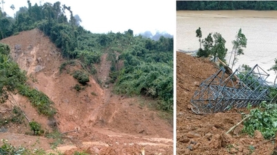
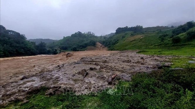
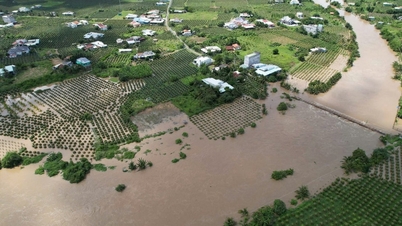
Localized heavy rains are likely to cause flash floods on small rivers and streams, landslides on slopes and inundation in low-lying areas. There is a risk of flash floods on small rivers and streams, landslides on slopes in many districts: Muong Te, Than Uyen (Lai Chau); Dien Bien, Dien Bien Dong, Muong Cha, Muong Nhe, Tuan Giao (Dien Bien); Mai Son, Muong La, Phu Yen, Song Ma, Son La city (Son La); Bac Ha, Bao Thang, Bao Yen ( Lao Cai); Luc Yen, Mu Cang Chai, Van Yen, Yen Binh (Yen Bai); Bac Me, Bac Quang, Dong Van, Hoang Su Phi, Meo Vac, Quan Ba, Quang Binh, Ha Giang city, Vi Xuyen, Xin Man, Yen Minh (Ha Giang); Chiem Hoa, Ham Yen, Lam Binh, Na Hang (Tuyen Quang).
Flash floods and landslides can have very negative impacts on the environment, threaten people's lives; cause local traffic congestion, affect the movement of vehicles; destroy civil and economic works, causing damage to production and socio-economic activities.
Regarding the tropical depression in the East Sea, at 1:00 a.m. on June 25, the center of the tropical depression was located at about 16.7 degrees North latitude; 115.6 degrees East longitude, about 440km east of Hoang Sa archipelago. The strongest wind near the center of the tropical depression reached level 6 (39-49km/h), gusting to level 8. This system is moving northwest at a speed of about 15km/h.
It is forecasted that by 1 a.m. on June 26, the tropical depression will move in the West-Northwest direction at a speed of 15-20 km/h and is likely to strengthen. At this time, the center of the tropical depression will be located at about 18.6 degrees North latitude; 112.7 degrees East longitude, about 260 km north of the Paracel Islands. The strongest wind will reach level 6-7, gusting to level 9.
The dangerous area in the East Sea in the next 24 hours with strong winds from level 6 or higher, gusting from level 8 or higher is located in the area from latitude 15.5 to 19.5 degrees North and from longitude 111.5 to 116.5 degrees East. The level of risk of natural disasters due to strong winds at sea is level 3.
")
At 1:00 a.m. on June 27, the tropical depression continued to move northwest at a speed of about 15 km/h. The center of the tropical depression was located at about 21.0 degrees North latitude; 110.6 degrees East longitude, in the sea east of Leizhou peninsula (China). The intensity remained at level 6-7, gusting to level 9. The danger zone expanded to the north from latitude 17.5 degrees and above and from longitude 109.5 to 113.5 degrees East longitude. Natural disaster risk continued to maintain level 3.
From the next 48 to 72 hours, the tropical depression tends to move in the North-Northwest direction, speed 15-20 km/h and is likely to gradually weaken. At sea, the North East Sea area (including Hoang Sa archipelago) will have thunderstorms and strong winds of level 6-7, gusts of level 9, rough seas. Waves are 2-4 m high. Ships operating in the above-mentioned dangerous areas are likely to be affected by thunderstorms, whirlwinds, strong winds, and big waves.
Specific weather in each region on June 25
Hanoi capital
- Cloudy, sunny during the day, showers and thunderstorms in some places in the evening and at night. Southeast to South wind level 2-3. During thunderstorms, there is a possibility of tornadoes, lightning and strong gusts of wind.
- Lowest temperature from 26-28 degrees Celsius, highest from 32-34 degrees Celsius.
Northwest
- Cloudy, scattered showers and thunderstorms; scattered showers and thunderstorms in the late afternoon and evening, with some areas experiencing heavy to very heavy rain. Light wind. Thunderstorms may include tornadoes, lightning, hail, and strong gusts of wind.
The lowest temperature is from 24-27 degrees Celsius, in the Northwest region it is 22-25 degrees Celsius, in some places it is below 21 degrees Celsius; the highest temperature is from 30-33 degrees Celsius, in some places it is above 33 degrees Celsius.
Northeast
- Cloudy, scattered showers and thunderstorms; in the late afternoon and at night in the mountainous and midland areas, scattered showers and thunderstorms, locally heavy to very heavy rain. Southeast to South wind level 2-3. During thunderstorms, there is a possibility of tornadoes, lightning, hail and strong gusts of wind.
- Lowest temperature from 25-28 degrees Celsius, highest from 31-34 degrees Celsius.
Area from Thanh Hoa to Hue
- Cloudy, sunny during the day, hot in some places; showers and thunderstorms in some places in the evening and at night. Thunderstorms may cause tornadoes, lightning and strong gusts of wind.
- Lowest temperature from 25-28 degrees Celsius, highest from 32-35 degrees Celsius, some places above 35 degrees Celsius.
Area from Da Nang to Binh Thuan
- Cloudy, scattered showers and thunderstorms; scattered showers and thunderstorms in the late afternoon and evening, with some heavy rain in some places. Southwest wind level 2-3. Thunderstorms may cause tornadoes, lightning, and strong gusts of wind.
- Lowest temperature from 24-27 degrees Celsius, highest from 32-35 degrees Celsius.
Central Highlands
- Cloudy, scattered showers and thunderstorms; in the afternoon and evening there will be rain, moderate rain and scattered thunderstorms, locally heavy to very heavy rain in some places. Southwest wind level 2-3. During thunderstorms there is a possibility of tornadoes, lightning and strong gusts of wind.
- Lowest temperature from 20-23 degrees Celsius, highest from 27-30 degrees Celsius.
Southern Vietnam
- Cloudy, scattered showers and thunderstorms; in the afternoon and evening there will be rain, moderate rain and scattered thunderstorms, locally heavy to very heavy rain in some places. Southwest wind level 2-3. During thunderstorms there is a possibility of tornadoes, lightning and strong gusts of wind.
- Lowest temperature from 23-26 degrees Celsius, highest from 30-33 degrees Celsius.
Last night and early morning of June 25, in the Northern and Central Highlands regions, there were places with heavy to very heavy rain and thunderstorms. The rainfall from 7:00 p.m. on June 24 to 3:00 a.m. on June 25 was over 130mm in some places, such as: Lieu Do (Yen Bai) 233mm, Tien Nguyen (Ha Giang) 193.4mm, Dak Hring (Kon Tum) 136.2mm.../.
Source: https://baolaocai.vn/thoi-tiet-ngay-256-mua-lon-cuc-bo-nguy-co-lu-quet-mien-nui-bac-bo-post403797.html
![[Photo] Draft documents of the 14th Party Congress reach people at the Commune Cultural Post Offices](https://vphoto.vietnam.vn/thumb/1200x675/vietnam/resource/IMAGE/2025/10/28/1761642182616_du-thao-tai-tinh-hung-yen-4070-5235-jpg.webp)
![[Photo] Flooding on the right side of the gate, entrance to Hue Citadel](https://vphoto.vietnam.vn/thumb/1200x675/vietnam/resource/IMAGE/2025/10/28/1761660788143_ndo_br_gen-h-z7165069467254-74c71c36d0cb396744b678cec80552f0-2-jpg.webp)
![[Photo] National Assembly Chairman Tran Thanh Man received a delegation of the Social Democratic Party of Germany](https://vphoto.vietnam.vn/thumb/1200x675/vietnam/resource/IMAGE/2025/10/28/1761652150406_ndo_br_cover-3345-jpg.webp)


![[Photo] President Luong Cuong attends the 80th Anniversary of the Traditional Day of the Armed Forces of Military Region 3](https://vphoto.vietnam.vn/thumb/1200x675/vietnam/resource/IMAGE/2025/10/28/1761635584312_ndo_br_1-jpg.webp)


Comment (0)