
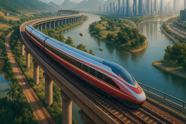
Perspective of Ben Thanh - Can Gio railway line - Photo: VinSpeed
According to the conclusion of the Standing Committee of the Ho Chi Minh City Party Committee, the Ben Thanh - Can Gio railway line is an important project in the development of urban transport and regional connectivity of the city, contributing to the formation of a new strategic transport axis according to the development orientation of the Party and State.
The investment in this project aims to meet the needs of passenger transport, create momentum for urban development and promote socio -economic development, in line with the orientation of expanding development space of Ho Chi Minh City.
The Standing Committee of the Ho Chi Minh City Party Committee agreed on the investment policy for the Ben Thanh - Can Gio railway project. At the same time, the Ho Chi Minh City Party Committee was assigned to lead the Ho Chi Minh City People's Committee to direct departments and branches to review the project's investment process and procedures to ensure strictness and compliance with legal regulations.
During the implementation process, it is necessary to strictly implement inspection and monitoring solutions to ensure the feasibility and progress of the project, while at the same time having solutions to minimize the impact on protective forests, landscapes, ecology and relics of the city.
The Ben Thanh - Can Gio railway project, implemented by VinSpeed High-speed Railway Investment and Development Joint Stock Company, has its starting point at September 23 Park (Ben Thanh Ward), and its ending point at a 39-hectare land plot adjacent to the Can Gio coastal urban tourism project (Can Gio Commune).
The project is more than 54km long, built with double track, 1435mm gauge, designed speed of 350km/h, load capacity of 17 tons/axle. In phase 1, the project has two stations including Ben Thanh, Can Gio and 4 stations in phase 2 (when needed) including Tan Thuan, Tan My, Nha Be, Binh Khanh stations.
The basic planned project route starts at Km0+00 in September 23rd Park, the route runs along the park land parallel to Le Lai Street, to Nguyen Thai Hoc Street, then changes direction along Ky Con Street, crossing Ben Nghe Canal.
After crossing Ben Nghe canal, the route turns northeast to enter Hoang Dieu street, the route follows Hoang Dieu street to the intersection with Nguyen Tat Thanh street, turns southeast, closely following the corridor of Doan Nhu Hai street.
The route goes straight through Nha Rong port area to near Tan Thuan 2 bridge area, the route turns southeast to Nguyen Van Linh street through the intersection with Nguyen Thi Thap street to Tan My ward.
The route continues south, crossing the intersection between Nguyen Van Linh Street and Phu My Bridge to Nguyen Luong Bang Street. The route turns southeast, going between Nguyen Luong Bang Street, Road 15B, Road D1 to Rach Dia River overpass at Km9+800 to Nha Be Commune.
After passing Nha Be commune, the route turns southeast through Van Phat Hung resettlement area, Phu Xuan residential area and crosses Soai Rap river to Binh Khanh commune and runs to Can Gio station.
Source: https://tuoitre.vn/thuong-vu-thanh-uy-tp-hcm-thong-nhat-chu-truong-dau-tu-du-an-duong-sat-ben-thanh-can-gio-20251206112243887.htm


![[Photo] 60th Anniversary of the Founding of the Vietnam Association of Photographic Artists](/_next/image?url=https%3A%2F%2Fvphoto.vietnam.vn%2Fthumb%2F1200x675%2Fvietnam%2Fresource%2FIMAGE%2F2025%2F12%2F05%2F1764935864512_a1-bnd-0841-9740-jpg.webp&w=3840&q=75)
![[Photo] National Assembly Chairman Tran Thanh Man attends the VinFuture 2025 Award Ceremony](/_next/image?url=https%3A%2F%2Fvphoto.vietnam.vn%2Fthumb%2F1200x675%2Fvietnam%2Fresource%2FIMAGE%2F2025%2F12%2F05%2F1764951162416_2628509768338816493-6995-jpg.webp&w=3840&q=75)


Comment (0)