
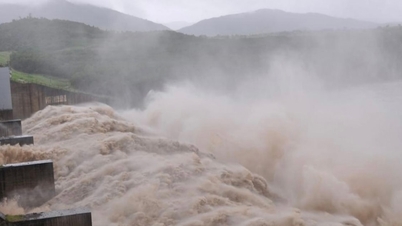
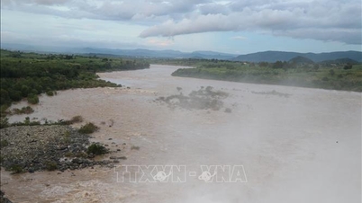
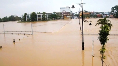
According to the Ninh Binh Provincial Hydrometeorological Station, the flood on the Hoang Long River at Ben De and Gian Khau; the Day River in Ninh Binh is rising. At 1:00 p.m. on September 12, 2024, the water level on the Hoang Long River at Ben De was 4.88m (0.88m above alert level 3), at Gian Khau 4.42m (0.72m above alert level 3); the Day River in Ninh Binh was 4.12m (0.62m above alert level 3), 0.18m above the historical flood peak in 2017.

Forecast for the next 12-24 hours: Water level on Hoang Long River at Ben De and Gian Khau continues to rise; at Ben De, it is likely to rise to 5.20-5.40m (above alert level 3: 1.20-1.40m); at Gian Khau, it will rise to 4.60-4.80m (above alert level 3: 0.90-1.10m). On Day River in Ninh Binh, it will continue to rise to 4.15-4.35m (above alert level 3: 0.65-0.85m).
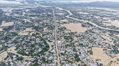
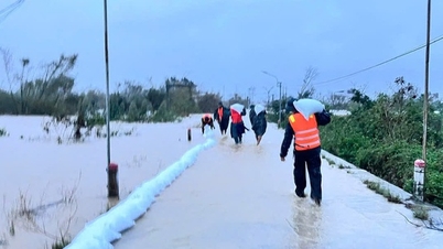
Rising river water levels combined with heavy rains have caused widespread flooding in the riverside areas and communes of Gia Tien, Gia Hung, Gia Thinh, Gia Phong, Gia Hoa; 2 schools in Kenh Ga village, Gia Thinh commune (outside the dike) of Gia Vien district; low-lying residential areas in Xich Tho, Gia Thuy, Lac Van, Gia Lam, Dong Phong, Gia Son, Thuong Hoa, Son Thanh communes of Nho Quan district; Truong Yen commune (Hoa Lu); Yen Lam, Yen Thai, Khanh Duong communes, Yen Thinh town (Yen Mo); Khanh Van commune (Yen Khanh); landslides at the foot of Huu Day dike in Hung Tien commune (Kim Son district); low-lying, low-lying, riverside areas in Ninh Binh city, coastal estuaries of Kim Son district. There is a high risk of flash floods and landslides in mountainous areas, steep slopes, communes of Nho Quan, Hoa Lu districts, Tam Diep city, Yen Mo, Gia Vien.
Floods in the river rise, combined with heavy rain; high risk of flash floods, landslides in mountainous areas, flooding of riverside areas, mid-river flats, widespread low-lying areas, affecting the safety of dykes, agricultural production, aquaculture and many local residential areas; can endanger people's lives and production, threaten people's lives and property and socio- economic activities...
Flood disaster risk level: level 3.
Ninh Binh Newspaper
Source: https://baoninhbinh.org.vn/tin-lu-khan-cap-tren-song-hoang-long-va-song-day-hoi-13h/d2024091212487459.htm


![[Photo] Cat Ba - Green island paradise](/_next/image?url=https%3A%2F%2Fvphoto.vietnam.vn%2Fthumb%2F1200x675%2Fvietnam%2Fresource%2FIMAGE%2F2025%2F12%2F04%2F1764821844074_ndo_br_1-dcbthienduongxanh638-jpg.webp&w=3840&q=75)


![[VIMC 40 days of lightning speed] Da Nang Port: Unity - Lightning speed - Breakthrough to the finish line](https://vphoto.vietnam.vn/thumb/402x226/vietnam/resource/IMAGE/2025/12/04/1764833540882_cdn_4-12-25.jpeg)


Comment (0)