
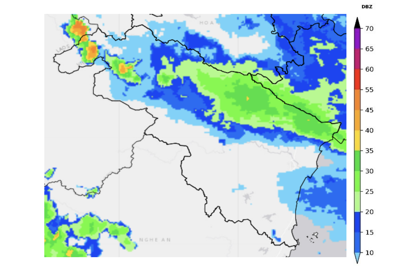
Weather radar image of Thanh Hoa province. (Source: National Hydrometeorological Network Center)
According to information from the Northern Hydrometeorological Station and Thanh Hoa Province Hydrometeorological Station, at 8:50 p.m. on July 20, convective clouds were developing at forecast locations such as Muong Lat, Hoi Xuan, Quan Son... Convective clouds at the Lao border and adjacent to Ninh Binh tended to move towards Thanh Hoa province.
Warning: In the current period to the next few hours, this convective cloud area will continue to develop, move and cause showers and thunderstorms for the above forecast points, then spread to the areas of Thiet Ong, Linh Son, Kim Tan, Cam Thuy.
During thunderstorms there is a possibility of tornadoes, lightning, hail and strong winds that can break trees, damage houses, traffic works and infrastructure, endangering human lives.
Beware of tornadoes and high waves at sea.
Warning level of natural disaster risk due to tornado, lightning, hail and gusts of wind: Level 1
News Reporter Group
Source: https://baothanhhoa.vn/canh-bao-dong-loc-set-mua-da-va-mua-lon-cuc-bo-tren-khu-vuc-tinh-thanh-hoa-255470.htm
![[Photo] 60th Anniversary of the Founding of the Vietnam Association of Photographic Artists](/_next/image?url=https%3A%2F%2Fvphoto.vietnam.vn%2Fthumb%2F1200x675%2Fvietnam%2Fresource%2FIMAGE%2F2025%2F12%2F05%2F1764935864512_a1-bnd-0841-9740-jpg.webp&w=3840&q=75)
![[Photo] National Assembly Chairman Tran Thanh Man attends the VinFuture 2025 Award Ceremony](/_next/image?url=https%3A%2F%2Fvphoto.vietnam.vn%2Fthumb%2F1200x675%2Fvietnam%2Fresource%2FIMAGE%2F2025%2F12%2F05%2F1764951162416_2628509768338816493-6995-jpg.webp&w=3840&q=75)


Comment (0)