

According to the National Center for Hydro-Meteorological Forecasting, at 10:00 a.m. on July 20, the center of storm No. 3 was at about 21.8 degrees North latitude; 114.2 degrees East longitude, in the northern sea area of the North East Sea, about 680km East of Quang Ninh - Hai Phong . The strongest wind near the center of the storm was level 11-12, gusting to level 15. The storm moved west at a speed of 20-25km/h.
The storm is forecast to continue moving west, then west southwest at a speed of 20-25km/h.
At 10:00 a.m. on July 21, in the eastern sea area of the Northern Gulf of Tonkin, the intensity was level 11, gusting to level 14.
At 10:00 a.m. on July 22, the coastal area of Quang Ninh - Thanh Hoa had intensity of level 10-11, gusting to level 14.
Warning from July 21-23, the Northeast, Northern Delta, Thanh Hoa, Nghe An will have very heavy rain from 200 to 350mm, locally more than 600mm. Other places in the North, Ha Tinh will have rain from 100 to 200mm, locally more than 300mm.
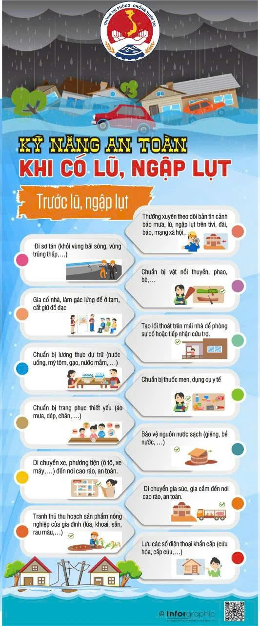
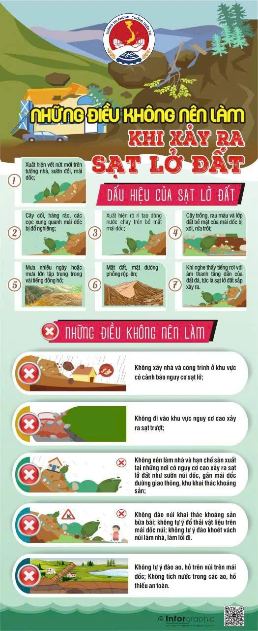
Heavy rains can cause flooding in low-lying areas; flash floods in small rivers and streams, and landslides on steep slopes.
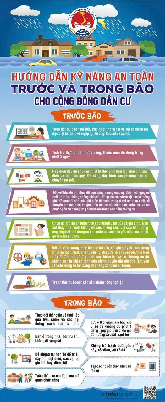
To ensure the safety of life and property from storms and floods after storms, the Department of Dyke Management and Natural Disaster Prevention and Control recommends that people should not be subjective and follow the following recommendations:
• Monitor forecasts, warnings, and updates on storm developments to proactively prevent and avoid them.
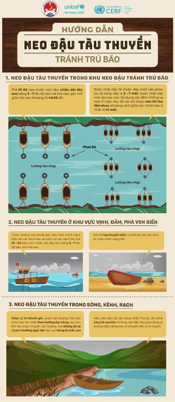
• Ensure safety of boats at anchorage, protect fishery cages and rafts, especially people on the islands; absolutely do not stay on anchored boats, tourist boats, watchtowers, cages, rafts, or aquaculture areas when the storm makes landfall.
• Ensure safety when traveling during the rainy and stormy season: regularly monitor weather developments, warn of natural disasters, proactively postpone or cancel trips when the weather is bad to ensure safety; avoid traveling to coastal areas, islands, mountainous areas or places at risk of landslides and flash floods. Absolutely do not go out when a storm is making landfall, except in emergency cases and with specific instructions from the authorities.
• Identify the safest shelter for all family members; proactively evacuate when necessary or as required by local authorities.
• Proactively stock up on food, water, medicine, and necessary supplies.
• Reinforce and prop up houses; trim tree branches; remove billboards and posters that pose a safety risk; ensure the safety of construction sites.
• Reinforce livestock and poultry barns; take advantage of early harvest of agricultural and aquatic products according to the motto "green at home is better than old in the fields".
• Beware of rain, floods, and inundation in some low-lying areas, urban areas, and flash floods and landslides in mountainous areas; beware of rising water in coastal areas and river mouths.
• Keep assets high, keep important documents in a safe place, move vehicles to high terrain.
• Proactively clear drainage systems near your home or residential area to create flood escape routes; notify authorities when there are problems with drainage blockages or deep flooding; do not park in areas at risk of flooding; be on guard against flooding in apartment basements.
• Save emergency phone numbers for use in case of emergency.


Source: Department of Dyke Management and Disaster Prevention and Control
Source: https://baothanhhoa.vn/tuan-thu-10-khuyen-cao-de-dam-bao-an-toan-truoc-trong-va-sau-bao-255432.htm


![[Photo] National Assembly Chairman Tran Thanh Man attends the VinFuture 2025 Award Ceremony](/_next/image?url=https%3A%2F%2Fvphoto.vietnam.vn%2Fthumb%2F1200x675%2Fvietnam%2Fresource%2FIMAGE%2F2025%2F12%2F05%2F1764951162416_2628509768338816493-6995-jpg.webp&w=3840&q=75)
![[Photo] 60th Anniversary of the Founding of the Vietnam Association of Photographic Artists](/_next/image?url=https%3A%2F%2Fvphoto.vietnam.vn%2Fthumb%2F1200x675%2Fvietnam%2Fresource%2FIMAGE%2F2025%2F12%2F05%2F1764935864512_a1-bnd-0841-9740-jpg.webp&w=3840&q=75)


Comment (0)