
Latest tropical depression news
According to the National Center for Hydro-Meteorological Forecasting, a tropical depression is currently active in the sea east of Luzon Island (Philippines).
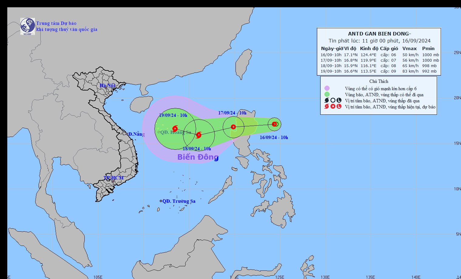
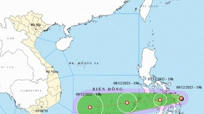
Update on the location and path of the latest tropical depression. Photo: NCHMF
At 10:00 a.m. on September 16, the center of the tropical depression was at about 17.1 degrees North latitude; 124.4 degrees East longitude. The strongest wind near the center of the tropical depression was level 6-7 (39-61 km/h), gusting to level 9; moving mainly west at about 15 km/h.
In addition, according to the Japan Meteorological Agency (JMA), the low pressure area north of Luzon Island of the Philippines has strengthened into a tropical depression and is moving towards the East Sea, possibly strengthening into storm No. 4 .
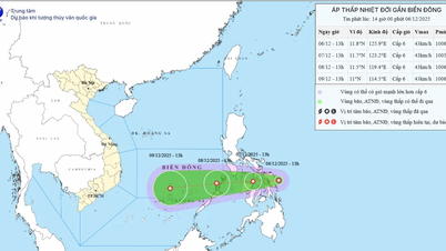
Forecast of tropical depression developments in the next 24 to 48 hours.
Forecast time | Direction, speed | Location | Intensity | Danger zone | Disaster Risk Level (Affected Area) |
10:00 a.m. September 17 | West, 15-20km/h, moving into the East Sea | 16.8 N-119.9E; on the western coastal area of Lu Dong island | Level 7, level 9 jerk | 15.0N-19.0N; East of longitude 118E | Level 3: Eastern area of the North East Sea |
10:00 a.m. September 18 | West Southwest about 20km/h, strengthening into a storm | 15.9N-116.1E; about 400km East Southeast of Hoang Sa archipelago | Level 8, level 10 | 14.0N-18.0N; 114.0-118.0E | Level 3: Eastern area of the North East Sea |
In the next 48 to 72 hours, the storm is likely to change direction, moving West Northwest, traveling 10-15km per hour.
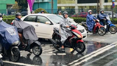
Forecast of the impact of the tropical depression: From the morning of September 17, the eastern sea of the North East Sea will have showers and thunderstorms, strong winds of level 7 (50-61km/h), gusts of level 9 (75-88km/h), and rough seas.
Rising water, big waves: The eastern sea area of the North East Sea has waves 2.0-4.0m high.
The National Center for Hydro-Meteorological Forecasting said: Currently, in the Gulf of Tonkin, the sea area from Quang Tri to Ca Mau, Ca Mau to Kien Giang , the Gulf of Thailand, the eastern sea area of the northern East Sea, the central and southern East Sea (including the sea area of Truong Sa archipelago) there are showers and thunderstorms. During the thunderstorms, there is a possibility of tornadoes and strong gusts of wind of level 7 - 8.
Currently, the tide level in the western coastal area of the South is high, it is necessary to guard against abnormal water level rise causing sea dike erosion.
On September 17, the sea area from Ninh Thuan to Ca Mau, the northern East Sea area (including the sea area of Hoang Sa archipelago), the southern sea area between the East Sea and the southern East Sea area (including the sea area of Truong Sa archipelago) will have strong southwest winds of level 6, sometimes level 7, gusting to level 8 - 9, rough seas; waves 3 - 5 m high.
Source: https://danviet.vn/khan-ap-thap-nhiet-doi-sap-vao-bien-dong-kha-nang-cao-thanh-bao-so-4-20240916112410091.htm

![[Photo] General Secretary To Lam receives the Director of the Academy of Public Administration and National Economy under the President of the Russian Federation](/_next/image?url=https%3A%2F%2Fvphoto.vietnam.vn%2Fthumb%2F1200x675%2Fvietnam%2Fresource%2FIMAGE%2F2025%2F12%2F08%2F1765200203892_a1-bnd-0933-4198-jpg.webp&w=3840&q=75)


Comment (0)