
From 4:00 AM on December 25th to 4:00 PM on December 25th, the storm moved in a west-southwest direction at a speed of 10-15 km/h and gradually weakened into a tropical depression.
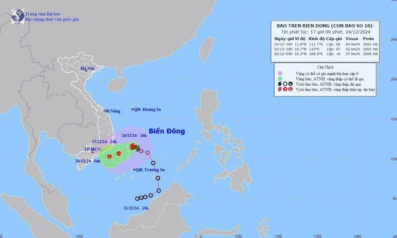
According to the National Center for Meteorological and Hydrological Forecasting, at 4:00 AM on December 25th, the typhoon's center was located at approximately 10.9 degrees North latitude and 110.7 degrees East longitude, in the southwestern part of the South China Sea. The strongest winds near the center of the typhoon were at level 8 (62-74 km/h), with gusts up to level 10; the typhoon was moving in a west-southwest direction at a speed of about 10 km/h.
From 4:00 AM on December 25th to 4:00 PM on December 25th, the storm moved in a west-southwest direction at a speed of 10-15 km/h and gradually weakened into a tropical depression. From 4:00 PM on December 25th to 4:00 AM on December 26th, the tropical depression moved in a west-southwest direction at a speed of 10-15 km/h and weakened into a low-pressure area.
Due to the influence of the storm, on December 25th, both day and night, the central area of the East Sea and the northwestern sea area of the South China Sea (including the northwestern sea area of the Spratly Islands), from Quang Tri to Binh Thuan, will experience showers and thunderstorms, with the possibility of tornadoes and strong gusts of wind during the thunderstorms.
Warning: On December 26th, day and night, the northern South China Sea (including the waters around the Paracel Islands) will experience strong northeasterly winds of force 6, occasionally reaching force 7 at night, with gusts of force 8-9, causing rough seas; wave heights will be 2-4.5m. The sea area from Khanh Hoa to Binh Thuan will have northeasterly winds of force 5, occasionally reaching force 6, with gusts of force 7. The sea will be rough. Wave heights will be 2-4m. The level of natural disaster risk due to strong winds at sea is level 2; however, the southwestern sea area of the central South China Sea and the northwestern sea area of the southern South China Sea (including the northwestern sea area of the Spratly Islands), and the sea area from Khanh Hoa to Ba Ria Vung Tau will be level 3.
On land, during the day and night of December 25th, the area from Binh Dinh to Ninh Thuan will experience moderate to heavy rain, with localized very heavy rain and thunderstorms, with rainfall generally ranging from 0-50mm. Additionally, Quang Nam , Quang Ngai, and Binh Thuan will have rain and showers, with localized heavy rain and thunderstorms, with rainfall generally ranging from 10-30mm, and localized areas exceeding 50mm. Warning: from December 26th onwards, heavy rain will gradually decrease. The level of natural disaster risk due to heavy rain is level 1.
Weather forecast for the regions on December 25th, day and night: Northwest Vietnam
- There will be scattered rain, with fog and light mist in the early morning, clearing up with sunshine in the afternoon. Light winds. Cold weather, with some areas experiencing severe cold.
- Lowest temperatures 12-15 degrees Celsius, some places below 12 degrees Celsius; in the Northwest region 10-13 degrees Celsius, some places below 9 degrees Celsius. Highest temperatures 20-23 degrees Celsius, some places below 19 degrees Celsius.
Northeastern Vietnam
- There will be scattered rain, with fog and light mist in the early morning, clearing up with sunshine in the afternoon. Northeast winds at level 2-3. Cold weather, with some areas in the mountains experiencing severe cold.
- Lowest temperatures 13-16 degrees Celsius; in mountainous areas, temperatures may drop below 11-13 degrees Celsius, and in some places below 10 degrees Celsius. Highest temperatures 20-23 degrees Celsius, with some places exceeding 23 degrees Celsius.
Hanoi, the capital city
- There will be scattered rain, with fog and light mist in the early morning, clearing up with sunshine in the afternoon. Northeast wind at level 2-3. Cold weather.
- Lowest temperature 14-16 degrees Celsius. Highest temperature 21-23 degrees Celsius.
Provinces from Thanh Hoa to Thua Thien-Hue
- Cloudy, with scattered rain in the North, some fog in the early morning, clearing up with sunshine in the afternoon; scattered rain and showers in the South. North to Northwest winds, 2-3 Beaufort scale. Cold weather.
- Lowest temperature 15-18 degrees Celsius. Highest temperature 19-22 degrees Celsius, with some areas in the North exceeding 22 degrees Celsius.
Provinces and cities from Da Nang to Binh Thuan
- Cloudy, with rain, showers, and locally heavy rain and thunderstorms; particularly in the area from Binh Dinh to Khanh Hoa, there will be moderate to heavy rain, with locally very heavy rain and thunderstorms. North to Northwest winds at level 2-3, with some areas in the South at level 4-5. The North will be cold, and there is a possibility of tornadoes, lightning, and strong gusts of wind during thunderstorms.
- Lowest temperatures: 19-22°C in the North, 22-24°C in the South. Highest temperatures: 21-24°C in the North; 25-28°C in the South, with some areas exceeding 28°C.
Central Highlands
- There will be rain, scattered showers, and thunderstorms in some areas. Northeast winds at level 2-3. Cold weather in the early morning and at night; there is a possibility of tornadoes, lightning, and strong gusts of wind during thunderstorms.
- Lowest temperatures 17-20 degrees Celsius, in some places below 16 degrees Celsius. Highest temperatures 23-26 degrees Celsius.
Southern Vietnam
- Showers in some areas. Northeast wind, force 2-3.
- Lowest temperature 21-24 degrees Celsius. Highest temperature 28-31 degrees Celsius, with some areas exceeding 31 degrees Celsius.
Source: VNA
Source: https://baophutho.vn/thoi-tiet-hom-nay-25-12-bao-so-10-suy-yeu-thanh-ap-thap-nhiet-doi-225194.htm


Comment (0)