
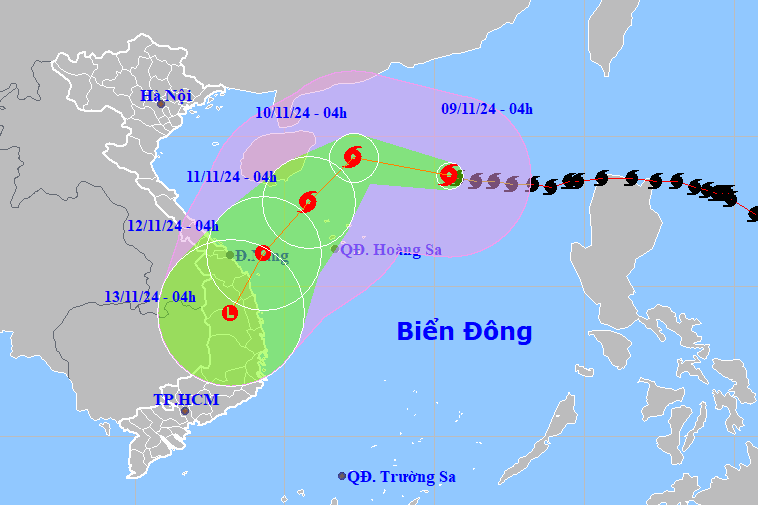
Typhoon Yinxing (Typhoon No. 7) has maintained its peak intensity of 14, with gusts reaching level 17, continuously for more than a day since entering the East Sea, and is currently more than 400km from the Hoang Sa (Paracel) Islands. It is forecast that the typhoon will weaken rapidly upon encountering cold air and head towards the mainland of Quang Nam – Binh Dinh provinces.
According to the National Center for Hydro-Meteorological Forecasting, as of 10:00 AM today (November 9th), the center of Typhoon Yinxing (Typhoon No. 7) was located in the northern part of the East Sea, approximately 415km northeast of the Hoang Sa (Paracel) Islands. The strongest winds near the center of the typhoon reached level 14 (150-166 km/h), with gusts up to level 17. It is moving in a west-northwest direction at a speed of about 15 km/h.
Thus, since Typhoon Yinxing entered the South China Sea, becoming the 7th typhoon of 2024 in the early morning of November 8th, it has continuously maintained a maximum intensity of level 14, with gusts up to level 17.
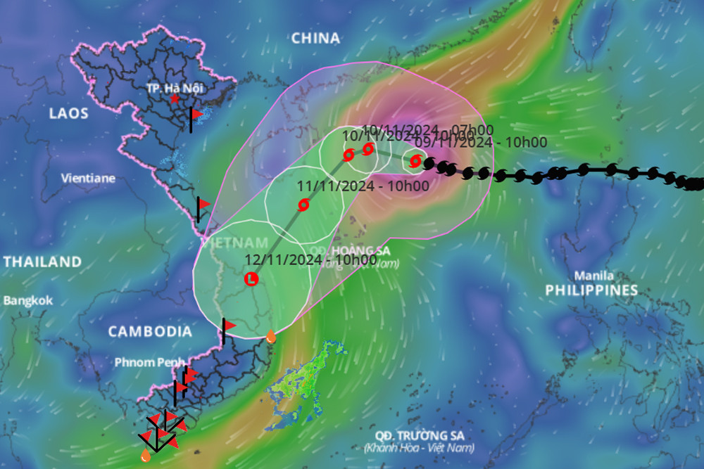
Over the next 24 hours, Typhoon No. 7 will maintain its direction of movement at a speed of 10-15 km/h. By 10:00 AM tomorrow (November 10th), the typhoon's center will be located in the northwestern part of the North East Sea, approximately 290 km north of the Hoang Sa archipelago. Notably, the typhoon's intensity is trending downwards, to level 12-13, with gusts up to level 16.
Subsequently, the storm changed direction, moving southwest at a speed of approximately 10-15 km/h and weakening rapidly. By 10:00 AM on November 11th, the storm's center was located about 160 km northwest of the Hoang Sa archipelago; it continued to weaken to level 10, with gusts up to level 13.
Forecasts indicate that over the next 24 hours, Typhoon Yinxing (Typhoon No. 7) will maintain its direction of movement at 15 km/h and gradually weaken into a tropical depression, then a low-pressure area; at 10:00 AM on November 12th, its center will be located over the inland areas of the provinces from Quang Nam to Binh Dinh.
Over the next 72 to 96 hours, the tropical depression moved southwest at approximately 10 km per hour and weakened into a low-pressure area.
According to meteorological experts, Typhoon No. 7 will maintain its strongest intensity today, then gradually weaken due to the influence of cold air, dry air, and low humidity.
Forecasts indicate that Typhoon No. 7 will weaken as it approaches the coast, but people and relevant agencies still need to be vigilant and not be complacent or negligent, even if the typhoon weakens into a tropical depression near the coast or even only causes light rain.
Due to the influence of typhoon number 7, the weather in the northern East Sea is characterized by strong winds of force 8-11, reaching force 12-14 in areas near the typhoon's center, with gusts up to force 17. Sea waves are 4-6 meters high, and 7-9 meters near the center, resulting in extremely rough seas.
Vessels operating in the aforementioned hazardous areas are susceptible to the effects of thunderstorms, tornadoes, strong winds, and high waves.
Typhoon Yinxing (Typhoon No. 7) still had gusts of wind up to level 17, but weakened as it entered the sea off Quang Tri - Quang Ngai provinces.


Comment (0)