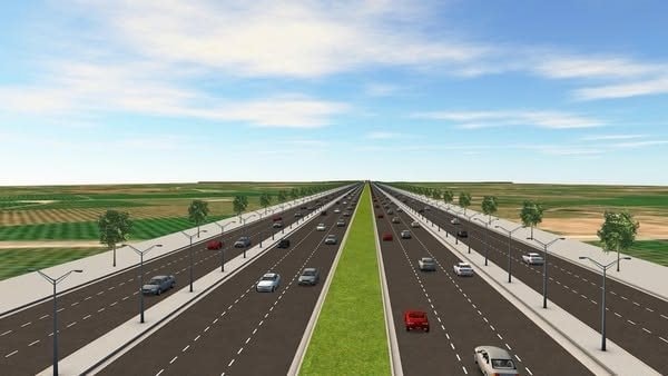
The project is highly anticipated by many residents...
The project to connect the expressway to the center of Phan Thiet ward and Phu Thuy ward is one of the projects of interest to local residents because it benefits many people. Currently, vehicles traveling on the North-South expressway in the southern area (towards Ho Chi Minh City) from Dau Giay to Phan Thiet ward must go through National Highway 1 - My Thanh, a section approximately 2.6 km long with 4 lanes, where motorcycles share the same lanes as motorized vehicles. Then, they continue along National Highway 1 (about 13 km) to reach Phan Thiet, which is quite inconvenient.
Since the expressway opened, the intersection with National Highway 1 (Ba Bau) has frequently experienced traffic congestion, especially on weekends and holidays. Despite the short distance of only 16 km, travel time is approximately 30 minutes, not including the time spent in traffic jams or accidents, which can extend the delay to nearly an hour. For traffic coming from the North, heading towards Khanh Hoa via the Vinh Hao - Phan Thiet expressway to the center of Phan Thiet ward, one must use the narrow National Highway 28, with only two lanes for motorized vehicles, taking over 30 minutes. This somewhat affects the effectiveness of the North-South expressway investment, especially after Binh Thuan merged with Lam Dong province, leading to increased travel demand from residents, officials, and employees, and potentially increasing the risk of traffic accidents.
According to the Provincial Transportation Project Management Board, in order to proactively connect important national transportation routes with the provincial center, open up new spaces, and contribute to promoting the development of the East-West economic corridor in the coastal area, Lam Dong province has implemented the project of connecting the center of Phan Thiet ward with the North-South high-speed railway line. The project has a length of approximately 12.5 km (including the North-South expressway overpass interchange and access roads to and from the expressway), with a hot asphalt concrete pavement structure, and is being invested in two sections: The first section from Km0+000 - Km1+000: The road cross-section is 37 m wide, with a road width of 10.5 m on each side, a 4 m wide median strip, and 6 m wide sidewalks on each side, including the investment in technical infrastructure. Section from Km1+000 to the end of the route: Land clearance will be carried out according to the scale of the complete road (12 lanes, 79 m wide cross-section). In the initial phase, 6 lanes for motorized vehicles will be added, along with 10 m wide sidewalks and technical infrastructure. Two new reinforced concrete bridges will be constructed along the route.
In addition, the project will also reclaim land along both sides of the road, ranging from 50 to 100 meters depending on the location (measured from the edge of the sidewalk), to be used for investment. The project has a land clearance scope of approximately 242 hectares (including the road section and land reclamation along both sides of the route). The total investment is expected to be nearly 5,000 billion VND, classifying it as a Group A project (of which compensation, support, and resettlement costs are over 2,700 billion VND), with a project implementation period of 5 years...
Assign specific tasks to implement
The Provincial People's Committee has issued a document (No. 211 dated September 9th) assigning specific tasks to relevant units to implement the project. Accordingly, the Provincial Transportation Project Management Board (the investor) is urged to promptly review and develop a project implementation schedule based on the key milestones proposed by the Provincial Transportation Project Management Board. Specifically, the investment project approval should be completed in December 2025; the approval of the construction drawings and cost estimates should be completed in June 2026; the contractor selection should be organized in August 2026; and the project should be completed in 2028.
Simultaneously, coordinate with the Department of Construction and other relevant departments and agencies to determine the implementation phase of the project boundary demarcation work, promptly deploy the project boundary demarcation, and hand it over to the Provincial Land Fund Development Center and the People's Committee of Binh Thuan Ward to organize the preparation of cadastral records to serve compensation and land clearance work and to carry out state management of land in accordance with regulations. Accelerate the completion of procedures for selecting consulting contractors, preparing environmental impact assessments and survey consulting, and preparing feasibility study reports for the project to be submitted to competent authorities for appraisal and approval of the investment project. Proactively plan and identify key areas and priority locations requiring land clearance in advance to closely coordinate with the Provincial Land Fund Development Center and the People's Committee of Binh Thuan Ward in the process of compensation and land clearance for the project.
The Department of Construction supports Binh Thuan ward in organizing the preparation of zoning plans and detailed construction plans for resettlement areas serving the project. It also researches and proposes planning for several resettlement areas to serve the compensation, support, and resettlement needs of the project. Furthermore, it effectively manages state land use, and conducts information and communication campaigns regarding the project's investment objectives and policies, ensuring that residents in the project area are aware, cooperate, and agree with the project's implementation.
The Vinh Hao - Phan Thiet Expressway connecting road project begins in Binh Thuan ward and extends to the intersection with Le Duan street (at the intersection with Truong Chinh street). From Le Duan street, it connects to Nguyen Tat Thanh street, forming a main east-west axis, linking the expressway to the center of Phan Thiet ward with important internal and external transportation hubs, opening up new development space to promote the socio-economic development of the locality... Specifically, from the Le Duan connecting road, it continues to other important roads such as Thu Khoa Huan - Hung Vuong road leading to Mui Ne National Tourist Area. At the same time, it connects to Nguyen Tat Thanh road leading to Doi Duong - Thuong Chanh beach; With Tran Hung Dao road leading to the Tien Thanh tourist area, then to La Gi, Ke Ga, Ham Tan, etc., this route will be very important in connecting regions, creating space for economic and commercial development, and increasing the value of land on both sides of the route, as well as land reserved for the construction of other commercial areas.
The Vinh Hao - Phan Thiet Expressway connecting road project begins in Binh Thuan ward and extends to the intersection with Le Duan street (at the intersection with Truong Chinh street). From Le Duan street, it connects to Nguyen Tat Thanh street, forming a main east-west axis linking the expressway to the center of Phan Thiet ward with important external and internal transportation hubs, opening up new development opportunities and promoting the socio-economic development of the locality.
Source: https://baolamdong.vn/phuong-an-trien-khai-tuyen-duong-12-lan-xe-ket-noi-giao-thong-quoc-gia-397964.html


![[Photo] Prime Minister Pham Minh Chinh holds a phone call with the CEO of Russia's Rosatom Corporation.](/_next/image?url=https%3A%2F%2Fvphoto.vietnam.vn%2Fthumb%2F1200x675%2Fvietnam%2Fresource%2FIMAGE%2F2025%2F12%2F11%2F1765464552365_dsc-5295-jpg.webp&w=3840&q=75)





































Comment (0)