
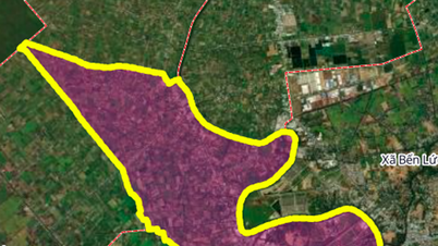
According to the land use planning adjustment map for the period 2021 - 2030 of Ben Luc district, Long An province, Thanh Loi commune will have a number of important new roads opened to complete the regional traffic infrastructure. Notably, a part of Ring Road 4 and a connecting road across the Vam Co Dong River.

Ring Road 4 passes through the commune
One of the key transport infrastructure projects passing through Thanh Loi commune is Ring Road 4, in the direction of Duc Hue district. This road section has an estimated length of about 9.8 km within the commune.
According to the plan, the route will cross Highway 02 (the section near Petrolimex gas station No. 77) and have a starting point near the Nam Bo Bridge relic site. This route is expected to create an inter-regional traffic connection axis, promoting socio-economic development for the western region of Long An province.


The route connects Ring Road 4 and crosses the Vam Co Dong River.
Besides Ring Road 4, the plan also identifies another important route with a length of about 5 km. This route has one end directly connected to the Ring Road 4 mentioned above.
The highlight of the project is that the route will cross the Vam Co Dong River, near the existing Ap 2 Thuan Hoa Ferry Terminal. Once completed, this project will help increase connectivity between the two river banks, creating favorable conditions for people to travel and transport goods.


Note: Planning information is based on the Land Use Planning Adjustment Map for the period 2021 - 2030 of Ben Luc district, Long An province. Planning information may change in the future according to adjustment decisions of competent authorities.
Source: https://baolamdong.vn/quy-hoach-2-tuyen-duong-lon-tai-xa-thanh-loi-long-an-399576.html


![[Photo] President Luong Cuong receives US Secretary of War Pete Hegseth](https://vphoto.vietnam.vn/thumb/1200x675/vietnam/resource/IMAGE/2025/11/02/1762089839868_ndo_br_1-jpg.webp)


![[Photo] Lam Dong: Images of damage after a suspected lake burst in Tuy Phong](https://vphoto.vietnam.vn/thumb/1200x675/vietnam/resource/IMAGE/2025/11/02/1762078736805_8e7f5424f473782d2162-5118-jpg.webp)


Comment (0)