
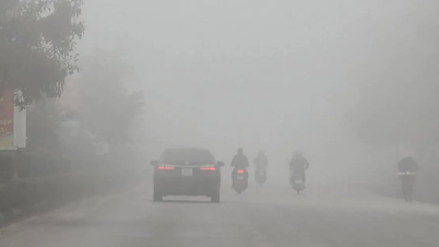
Over the next 24 hours, the Northeast and Thanh Hoa will experience moderate to heavy rain, with some areas receiving 50-130mm, and localized rainfall exceeding 250mm. Nghe An will receive 30-60mm, with some areas exceeding 120mm; Ha Tinh and Quang Tri will generally receive 20-50mm, with some areas exceeding 80mm. The Northwest, from Thua Thien-Hue to Lam Dong, and the Southern region will have scattered showers and thunderstorms, with localized rainfall exceeding 80mm, concentrated in the afternoon and evening. There is a risk of flash floods and landslides in mountainous areas, and urban flooding.
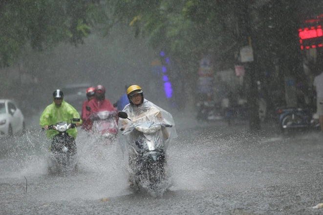
Heavy rain in Northern Vietnam and North Central Vietnam.
At sea, on the morning of August 18th, the center of the tropical depression was located south of Hainan Island (China), with winds of force 6, gusting to force 8, moving northwest at 15 km/h. The circulation of the low-pressure system combined with the southwest monsoon caused strong winds in many places: Phu Quy Island with winds of force 6, gusting to force 7-8; Bach Long Vi Island with gusts of force 7; and Hon Ngu Island with gusts of force 8.
The forecast for the next 24 hours indicates that the Gulf of Tonkin will experience increasingly strong winds, reaching level 6 with gusts up to level 8; rough seas with waves 2.0 - 3.0m high. The eastern area from southern Quang Tri to Hue will have winds of level 6 with gusts up to level 8, rough seas, and waves 2 - 3m high, with winds gradually decreasing at night.
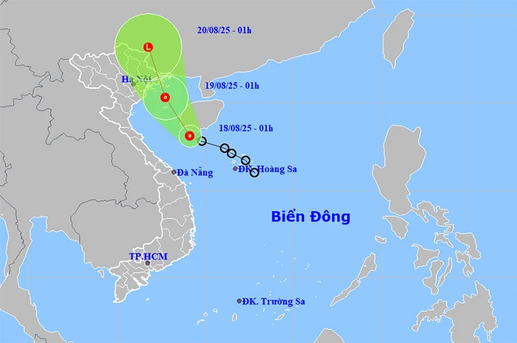
Location and path of the tropical depression. Photo: thoitietvietnam
From Khanh Hoa to Lam Dong, the northwestern area of the East Sea (including the Hoang Sa sea area) and the central East Sea will experience southwest to south winds of force 5, sometimes force 6, gusting to 7-8; waves will be 2.0-3.5m high, with rough seas.
In addition, most sea areas including the North, Central and South East Sea, the Gulf of Tonkin, the sea area from southern Quang Tri to Ca Mau, from Ca Mau to An Giang and the Gulf of Thailand will experience showers and thunderstorms. During thunderstorms, there is a possibility of tornadoes, strong gusts of wind, and sea waves that could exceed 3.5m.
Weather forecast for areas across the country:
Hanoi, the capital city, will be cloudy with moderate to heavy rain and thunderstorms. Winds will be from the northeast to north at speeds of 2-3. During thunderstorms, there is a possibility of tornadoes, lightning, and strong gusts of wind. The lowest temperature will be 24-26°C, and the highest temperature will be 28-30°C.
The Northwest region will be cloudy with scattered showers and thunderstorms, with some areas experiencing heavy rain (rain concentrated in the afternoon and evening). Light winds. During thunderstorms, there is a possibility of tornadoes, lightning, hail, and strong gusts of wind. The lowest temperature will be 22-25°C, with some areas below 21°C. The highest temperature will be 29-32°C, with some areas above 32°C.
The northeastern provinces of Vietnam will be cloudy with moderate to heavy rain and thunderstorms, with very heavy rain in some areas. Winds will be from the northeast to north at speeds of 2-3. During thunderstorms, there is a possibility of tornadoes, lightning, hail, and strong gusts of wind. The lowest temperature will be 23-26°C, with some mountainous areas below 22°C. The highest temperature will be 28-31°C, with some areas exceeding 31°C.
Provinces from Thanh Hoa to Hue will be cloudy with moderate to heavy rain and thunderstorms, with very heavy rain in some areas; Hue will experience scattered showers and thunderstorms, with heavy to very heavy rain in some localized areas. North to northwest winds will be at level 2-3. During thunderstorms, there is a possibility of tornadoes, lightning, hail, and strong gusts of wind. The lowest temperature will be 23-26°C. The highest temperature will be 27-29°C in the North and 29-31°C in the South.
The South Central Coastal region will be cloudy with scattered showers and thunderstorms in some areas, especially in the afternoon and evening with scattered showers and thunderstorms, and locally heavy to very heavy rain. Winds will be from the west to southwest at speeds of 2-3. During thunderstorms, there is a possibility of tornadoes, lightning, hail, and strong gusts of wind. The lowest temperature will be 24-27°C. The highest temperature will be 31-34°C, with some areas exceeding 34°C.
The Central Highlands will be cloudy with scattered showers and thunderstorms in some areas, especially in the afternoon and evening with scattered showers and thunderstorms, and locally heavy to very heavy rain. Southwesterly winds will be at level 2-3. During thunderstorms, there is a possibility of tornadoes, lightning, hail, and strong gusts of wind. The lowest temperature will be 20-23°C. The highest temperature will be 26-29°C.
Southern Vietnam will be cloudy with scattered showers and thunderstorms in some areas, especially in the afternoon and evening with scattered showers and thunderstorms, and locally heavy to very heavy rain. Southwesterly winds will be at level 2-3. During thunderstorms, there is a possibility of tornadoes, lightning, hail, and strong gusts of wind. The lowest temperature will be 23-26°C. The highest temperature will be 31-34°C.
Ho Chi Minh City will be cloudy with scattered showers and thunderstorms in some areas, especially in the afternoon and evening with scattered showers and thunderstorms, and locally heavy to very heavy rain. Southwesterly winds will be at level 2-3. During thunderstorms, there is a possibility of tornadoes, lightning, hail, and strong gusts of wind. The lowest temperature will be 24-26°C. The highest temperature will be 31-34°C.
Source: baotintuc.vn
Source: https://baophutho.vn/thoi-tiet-ngay-18-8-bac-bo-va-bac-trung-bo-mua-lon-bien-dong-manh-238078.htm


Comment (0)