
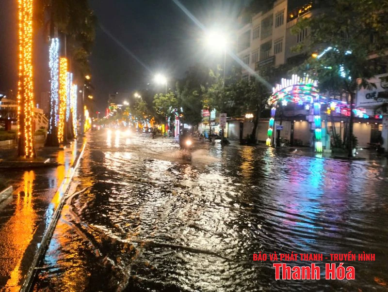
Phan Chu Trinh Street (Hac Thanh Ward, Thanh Hoa Province) was partially flooded due to heavy rain on the evening of July 19.
On the afternoon of July 19, the center of storm No. 3 was at about 20.7 degrees North latitude; 118.4 degrees East longitude (over 1,000km east of Ha Long Bay), the storm circulation was about 200-300km (from the storm center). The strongest wind near the storm center was level 10 (89-102km/h), gusting to level 12 and had not yet directly affected the Gulf of Tonkin.
The National Center for Hydro-Meteorological Forecasting explained that the cause of the heavy thunderstorms on the afternoon of July 19 in the North and the Gulf of Tonkin was due to the influence of the tropical convergence zone with its axis passing through the North, combined with the high temperature conditions in the North in the past 3 days, causing strong updrafts in the unstable conditions of the atmosphere, causing heavy thunderstorms.
This is a tropical thunderstorm system, which is a medium-sized thunderstorm cloud complex, often causing very heavy rain and dangerous weather phenomena.
Super thunderstorm systems range in diameter from a few kilometers to several hundred kilometers. They consist of multiple clusters of thunderstorms that combine to form a large system. They can last for hours, even 12-24 hours, and are stronger and longer lasting than individual thunderstorms.
Previously, in the marine weather forecast for the day and night of July 19, the National Center for Hydro-Meteorological Forecasting predicted that the sea area of the Gulf of Tonkin will have scattered showers and thunderstorms during the day and scattered showers and thunderstorms at night. There is a possibility of tornadoes and strong gusts of wind during the thunderstorms.
Regarding the weather and hydrological situation in the coming time, due to the influence of storm No. 3, from last night, July 19 and July 20, the Gulf of Tonkin, the North and Central East Sea (including the Hoang Sa special zone) will have showers and thunderstorms, especially the northern sea area of the North East Sea, and the Gulf of Thailand will have scattered showers and thunderstorms.
From the night of July 20 and July 21, the northern sea area of the North East Sea will have strong winds of level 8-9, the area near the storm's eye will have winds of level 10-12, gusting to level 15; waves 4-6m high; rough seas.
From July 21, the sea area in the eastern part of the Northern Gulf of Tonkin will have winds gradually increasing to level 6-7, then increasing to level 8-9, near the storm center level 10-11, gusting to level 13; waves 2-4m high, near the center 3-5m; rough seas.
NDS
Source: https://baothanhhoa.vn/mua-dong-o-bac-bo-chieu-19-7-khong-phai-do-anh-huong-bao-so-3-255385.htm
![[Photo] Ho Chi Minh City Youth Take Action for a Cleaner Environment](https://vphoto.vietnam.vn/thumb/1200x675/vietnam/resource/IMAGE/2025/11/04/1762233574890_550816358-1108586934787014-6430522970717297480-n-1-jpg.webp)
![[Photo] The road connecting Dong Nai with Ho Chi Minh City is still unfinished after 5 years of construction.](https://vphoto.vietnam.vn/thumb/1200x675/vietnam/resource/IMAGE/2025/11/04/1762241675985_ndo_br_dji-20251104104418-0635-d-resize-1295-jpg.webp)

![[Photo] Ca Mau "struggling" to cope with the highest tide of the year, forecast to exceed alert level 3](https://vphoto.vietnam.vn/thumb/1200x675/vietnam/resource/IMAGE/2025/11/04/1762235371445_ndo_br_trieu-cuong-2-6486-jpg.webp)
![[Photo] Panorama of the Patriotic Emulation Congress of Nhan Dan Newspaper for the period 2025-2030](https://vphoto.vietnam.vn/thumb/1200x675/vietnam/resource/IMAGE/2025/11/04/1762252775462_ndo_br_dhthiduayeuncbaond-6125-jpg.webp)


Comment (0)