
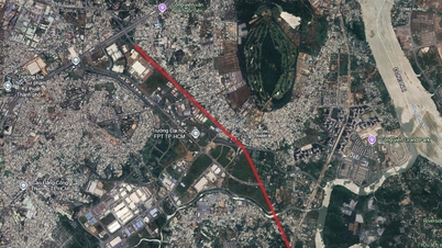
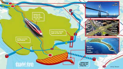
Overview of traffic planning of Long Huu commune
According to the land use planning adjustment map for the period 2021 - 2030 of the old Can Duoc district, Long Huu commune will have a number of new roads deployed to complete the traffic infrastructure of the area. Notably, a new section of Provincial Road 826D will be built.

Details of Provincial Road 826D to open
The planned important route is a section of Provincial Road 826D. This project plays a role in connecting existing roads and creating momentum for local socio -economic development.
Specifically, within Long Huu commune, this route is about 2.3 km long. The starting point of the route connects with Provincial Road 23, near Linh Phuoc Pagoda. The end point of the route will cross the Can Giuoc River, near Ba Chua Xu Temple, connecting with neighboring areas.

The implementation of this route is expected to help enhance connectivity, shorten travel time and promote trade in the region.

Note: The diagrams in the article are drawn relatively, based on the Land Use Planning Adjustment Map for the period 2021 - 2030 of the old Can Duoc district. Planning information may change in the future according to decisions of the competent authorities.
Source: https://baolamdong.vn/quy-hoach-duong-tinh-826d-qua-xa-long-huu-tay-ninh-406741.html

![[Photo] Parade to celebrate the 50th anniversary of Laos' National Day](/_next/image?url=https%3A%2F%2Fvphoto.vietnam.vn%2Fthumb%2F1200x675%2Fvietnam%2Fresource%2FIMAGE%2F2025%2F12%2F02%2F1764691918289_ndo_br_0-jpg.webp&w=3840&q=75)


![[Photo] Worshiping the Tuyet Son statue - a nearly 400-year-old treasure at Keo Pagoda](/_next/image?url=https%3A%2F%2Fvphoto.vietnam.vn%2Fthumb%2F1200x675%2Fvietnam%2Fresource%2FIMAGE%2F2025%2F12%2F02%2F1764679323086_ndo_br_tempimageomw0hi-4884-jpg.webp&w=3840&q=75)


Comment (0)