
On October 8, the Northern region and Thanh Hoa are forecast to continue to have scattered showers and thunderstorms, with rainfall ranging from 15-30mm, with some places experiencing over 60mm. In Hanoi , this morning saw moderate to heavy rain, with some spots experiencing over 70mm, but rainfall is forecast to gradually decrease in the afternoon and evening.
In the late afternoon and evening of the same day, scattered showers and thunderstorms will also occur in the Central Highlands and the South, with rainfall ranging from 15-30mm in general and over 70mm in some places. During thunderstorms, people should be on guard against dangerous weather phenomena such as tornadoes, lightning, hail and strong gusts of wind. Localized heavy rain in the North can cause flash floods on small rivers and streams, landslides on steep slopes and flooding in low-lying areas.

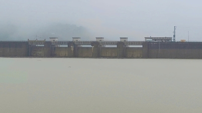
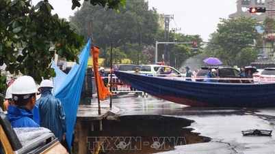
Currently, floods on Cau River and Thuong River ( Bac Ninh ) continue to rise; meanwhile, floods on Luc Nam River are slowly receding, water levels on other rivers in the North still tend to increase.
It is forecasted that in the next 12 hours, the flood on Cau River at Dap Cau station and Thuong River at Phu Lang Thuong station will exceed alarm level 3; in the upstream of Cau River (Thai Nguyen), the water level is about 0.19m above the historical flood level in 2024. In the next 24 hours, the flood on Thuong River may exceed the historical flood level in 1986 (7.52m), while the flood on Luc Nam River will gradually decrease and fluctuate at alarm level 1-2.
From now until October 9, floods on rivers in the Northern region will continue to rise. The flood peak on the Thai Binh River (Hai Phong) is likely to reach alert level 2; the Thao River (Lao Cai), Lo River (Tuyen Quang), Hoang Long River (Ninh Binh) will reach alert levels 1-2, with some places above alert level 2. The risk level of natural disasters due to floods is warned at level 3. Heavy rains and floods can cause flooding in low-lying areas along rivers, affecting transportation, aquaculture, agricultural production and people's lives.
At sea, the South China Sea (including the Truong Sa sea area) and the Gulf of Thailand are experiencing showers and thunderstorms. During the day and night of October 8, thunderstorms will continue in the central and southern China Sea, from Binh Thuan to Ca Mau, Ca Mau to Kien Giang. During thunderstorms, there is a possibility of tornadoes, strong gusts of wind of level 6-7, and waves over 2m high, posing a danger to ships operating offshore.
Weather forecast for regions across the country:
Hanoi capital is cloudy, with rain, moderate rain and thunderstorms in the morning, and heavy rain in some places; the rain will decrease later. Southeast wind level 2-3. During thunderstorms, there is a possibility of tornadoes, lightning, and strong gusts of wind. Lowest temperature 23-25 degrees Celsius. Highest temperature 29-31 degrees Celsius.
The Northwestern provinces are cloudy, with scattered showers and thunderstorms during the day, with some heavy rain in some places; scattered showers and thunderstorms at night. Light wind. During thunderstorms, there is a possibility of tornadoes, lightning and strong gusts of wind. The lowest temperature is 22-25 degrees Celsius, with some places below 21 degrees Celsius. The highest temperature is 27-30 degrees Celsius, with some places above 30 degrees Celsius.
The Northeastern region is cloudy, with scattered showers and thunderstorms during the day, with heavy rain in some places; scattered showers and thunderstorms at night. Southeast wind level 2-3. During thunderstorms, there is a possibility of tornadoes, lightning and strong gusts of wind. The lowest temperature is 22-25 degrees Celsius, in mountainous areas, some places below 21 degrees Celsius. The highest temperature is 28-31 degrees Celsius, some places above 31 degrees Celsius.
Provinces from Thanh Hoa to Hue will be cloudy with scattered showers and thunderstorms. Light winds. Thunderstorms may include tornadoes, lightning, and strong gusts of wind. Lowest temperature 23-26 degrees Celsius. Highest temperature 30-33 degrees Celsius.
The South Central Coast region is cloudy, sunny during the day, with showers and thunderstorms in some places in the evening and at night. Light wind. During thunderstorms, there is a possibility of tornadoes, lightning and strong gusts of wind. Lowest temperature 24-27 degrees Celsius. Highest temperature 31-34 degrees Celsius.
The Central Highlands is cloudy with scattered showers and thunderstorms; in the late afternoon and evening there will be scattered showers and thunderstorms, with some heavy rain in some places. Southwest wind level 2-3. During thunderstorms there is a possibility of tornadoes, lightning and strong gusts. Lowest temperature 19-22 degrees Celsius. Highest temperature 28-31 degrees Celsius, some places above 31 degrees Celsius.
The South is cloudy with scattered showers and thunderstorms; in the late afternoon and evening there will be scattered showers and thunderstorms, with some heavy rain in some places. Southwest wind level 2-3. During thunderstorms there is a possibility of tornadoes, lightning and strong gusts. Lowest temperature 23-26 degrees Celsius. Highest temperature 31-34 degrees Celsius.
Ho Chi Minh City is cloudy with scattered showers and thunderstorms; in the late afternoon and evening there will be scattered showers and thunderstorms, with some heavy rain in some places. Southwest wind level 2-3. During thunderstorms there is a possibility of tornadoes, lightning and strong gusts of wind. Lowest temperature 24-26 degrees Celsius. Highest temperature 31-33 degrees Celsius.
Source: https://baotintuc.vn/xa-hoi/thoi-weather-ngay-810-bac-bo-tiep-tuc-mua-lon-lu-tren-nhieu-song-vuot-muc-bao-dong-3-20251008054546421.htm


![[Photo] Worshiping the Tuyet Son statue - a nearly 400-year-old treasure at Keo Pagoda](/_next/image?url=https%3A%2F%2Fvphoto.vietnam.vn%2Fthumb%2F1200x675%2Fvietnam%2Fresource%2FIMAGE%2F2025%2F12%2F02%2F1764679323086_ndo_br_tempimageomw0hi-4884-jpg.webp&w=3840&q=75)
![[Photo] Parade to celebrate the 50th anniversary of Laos' National Day](/_next/image?url=https%3A%2F%2Fvphoto.vietnam.vn%2Fthumb%2F1200x675%2Fvietnam%2Fresource%2FIMAGE%2F2025%2F12%2F02%2F1764691918289_ndo_br_0-jpg.webp&w=3840&q=75)


Comment (0)