

According to the National Center for Hydro-Meteorological Forecasting, last night and early this morning (July 23), there was moderate rain and localized heavy rain in the North. The rainfall from 7:00 p.m. on July 22 to 3:00 a.m. on July 23 was over 40mm in some places, such as: Pu Danh station (Son La) 73.8mm, Cao Pha station ( Lao Cai ) 67.0mm, Lung Van station (Phu Tho) 46.0mm, ...
Forecast for the day and night of July 23, in the North, there will be scattered showers and thunderstorms, locally heavy rain with rainfall from 15-30mm, locally over 80mm. During thunderstorms, there is a possibility of tornadoes, lightning, hail and strong gusts of wind.
Heavy Rain Warning for Northern Vietnam, Thanh Hoa, and Nghe An : From July 24th to 25th, a widespread heavy rain event is likely to occur in Northern Vietnam, Thanh Hoa, and Nghe An, with rainfall amounts generally ranging from 60-120mm, and locally exceeding 200mm. There is a risk of heavy rainfall (> 90mm/3h). During thunderstorms, there is a possibility of tornadoes, lightning, hail, and strong gusts of wind. The level of natural disaster risk due to heavy rain, tornadoes, lightning, and hail is level 1.
Heavy rainfall is likely to cause flooding in low-lying areas, urban and industrial zones; flash floods on small rivers and streams, and landslides on slopes (real-time warning information on flash flood and landslide risk areas is provided online on the website of the National Meteorological and Hydrological Service at: https://luquetsatlo.nchmf.gov.vn and in separate flash flood and landslide warning bulletins).
Currently (July 23rd), after making landfall in Ninh Binh and Thanh Hoa provinces, Typhoon No. 3 has weakened and dissipated. Due to the influence of Typhoon No. 3, strong winds of level 10, gusting to level 12, were recorded in Bach Long Vi Special Zone; strong winds of level 9, gusting to level 11, in Co To Special Zone; strong winds of level 6, gusting to level 8, in Cat Ba (Cat Hai Special Zone); and strong winds of level 9, gusting to level 10, in Hon Dau ( Hai Phong ).
In addition, on the day and night of July 23, in the Gulf of Tonkin, the eastern sea area of the North and the middle of the East Sea, there will be showers and thunderstorms. During the thunderstorms, there is a possibility of tornadoes and strong gusts of wind.
Day and night 24/7: sea area from Khanh Hoa to Lam Dong, Central East Sea area has strong southwest wind level 6, gust level 7-8; waves 2.0-3.5m high; rough sea. Disaster risk level due to strong winds at sea: level 2.
All vessels operating in these areas are at high risk of being affected by cyclones, strong winds, and high waves.
Weather forecast for regions across the country on July 23:
Hanoi is cloudy with occasional showers and thunderstorms. Southeast to east winds at level 2-3. During thunderstorms, there is a possibility of tornadoes, lightning, and strong gusts of wind. Lowest temperature 24-26 degrees Celsius, highest 28-30 degrees Celsius.
Northwest region is cloudy with scattered showers and thunderstorms, locally heavy rain. Light wind. Thunderstorms may cause tornadoes, lightning and strong gusts of wind. Lowest temperature 21-24 degrees Celsius, some places below 21 degrees; highest 28-31 degrees Celsius.
Northeast region is cloudy with scattered showers and thunderstorms, locally heavy rain. Southeast to east wind force 2-3. During thunderstorms, there is a possibility of tornadoes, lightning and strong gusts of wind. Lowest temperature 24-27 degrees Celsius, highest 28-31 degrees Celsius, some places above 31 degrees.
The area from Thanh Hoa to Thua Thien Hue will be cloudy with scattered showers and thunderstorms in some places, especially in the north where there will be scattered showers and thunderstorms in some areas. South to southwest winds at level 2-3. During thunderstorms, there is a possibility of tornadoes, lightning, and strong gusts of wind. The lowest temperature will be 25-28 degrees Celsius, the highest 30-33 degrees Celsius, with some places exceeding 33 degrees.
The South Central Coast is cloudy with scattered showers and thunderstorms. Southwesterly winds at level 2-3. Thunderstorms may include tornadoes, lightning, hail, and strong gusts of wind. Lowest temperatures 26-29 degrees Celsius, highest 31-34 degrees Celsius, and some places above 34 degrees.
The Central Highlands is cloudy with scattered showers and thunderstorms, with scattered showers and thunderstorms in the afternoon and evening. Southwesterly winds at level 2-3. There is a possibility of tornadoes, lightning, and strong gusts of wind during thunderstorms. The lowest temperature is 20-23 degrees Celsius, the highest is 27-30 degrees Celsius, and some places are over 30 degrees Celsius.
The South is cloudy with scattered showers and thunderstorms, with scattered showers and thunderstorms in the afternoon and evening. Southwesterly winds at level 2-3. There is a possibility of tornadoes, lightning, and strong gusts of wind during thunderstorms. The lowest temperature is 23-26 degrees Celsius, the highest is 30-33 degrees Celsius, and some places are over 33 degrees.
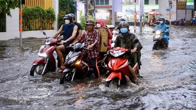
Ho Chi Minh City is cloudy, sunny during the day, with occasional showers and thunderstorms in the evening, and no rain at night. Southwest wind force 2-3. During thunderstorms, there is a possibility of tornadoes, lightning, and strong gusts of wind. Lowest temperature 24-26 degrees Celsius, highest 32-34 degrees Celsius.
Source: https://baolaocai.vn/nhieu-khu-vuc-mua-dong-nguy-co-sat-lo-cao-sau-bao-so-3-post649502.html

![[Photo] Closing Ceremony of the 10th Session of the 15th National Assembly](/_next/image?url=https%3A%2F%2Fvphoto.vietnam.vn%2Fthumb%2F1200x675%2Fvietnam%2Fresource%2FIMAGE%2F2025%2F12%2F11%2F1765448959967_image-1437-jpg.webp&w=3840&q=75)


![[Photo] Prime Minister Pham Minh Chinh holds a phone call with the CEO of Russia's Rosatom Corporation.](/_next/image?url=https%3A%2F%2Fvphoto.vietnam.vn%2Fthumb%2F1200x675%2Fvietnam%2Fresource%2FIMAGE%2F2025%2F12%2F11%2F1765464552365_dsc-5295-jpg.webp&w=3840&q=75)


![[OFFICIAL] MISA GROUP ANNOUNCES ITS PIONEERING BRAND POSITIONING IN BUILDING AGENTIC AI FOR BUSINESSES, HOUSEHOLDS, AND THE GOVERNMENT](https://vphoto.vietnam.vn/thumb/402x226/vietnam/resource/IMAGE/2025/12/11/1765444754256_agentic-ai_postfb-scaled.png)


Comment (0)