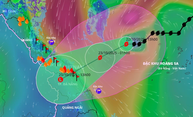
Updating information on storm No. 12, the National Center for Hydro-Meteorological Forecasting said that at 4:00 p.m. today, October 22, the center of the storm was located at about 17.1 degrees north latitude and 109.8 degrees east longitude, about 200 km east-northeast of Da Nang City.

Storm No. 12 is starting to weaken, many areas in the Central region are experiencing heavy rain before the storm. PHOTO: VNDMS
After many hours of maintaining its maximum intensity at level 10, storm No. 12 began to weaken. Storm No. 12 is at level 10 wind intensity, equivalent to a speed of 75 - 88 km/h, gusting to level 11. In the next 3 hours, the storm will move west-southwest, at a speed of about 10 km/h.
Due to the influence of cold air, storm No. 12 will continue to weaken rapidly as it gets closer to land. It is forecasted that by 1 a.m. tomorrow, October 23, storm No. 12 will be located about 100 km east-northeast of Da Nang City, at which point the storm's intensity will weaken to level 8.
Also according to the National Center for Hydro-Meteorological Forecasting, storm No. 12 continues to weaken rapidly. It is forecasted that on the morning of October 23, the storm will weaken into a tropical depression, move inland from Hue City to Quang Ngai Province, then continue to move to southern Laos, weakening into a low pressure area.
Storm No. 12 dissipates, but heavy rain continues in the Central region
The National Center for Hydro-Meteorological Forecasting warns that due to the influence of storm circulation No. 12 (storm Fengshen) combined with the strong strengthening of cold air, from this evening, on the mainland coastal provinces from Quang Tri to Da Nang City, winds will gradually increase to level 6, sometimes level 7, gusting to level 8 - 9.
In addition, due to the influence of storm circulation and cold air combined with easterly wind disturbances and the topographic effect of the Central region, from tonight, October 22 to 24, the provinces from Ha Tinh to Quang Ngai will have heavy rain.
Rainfall is forecast to be 100 - 250 mm, with some places experiencing heavy rain of over 350 mm; particularly in the southern Quang Tri, Hue City and Da Nang City, there will be very heavy rain. Total rainfall is forecast to be 400 - 600 mm, with some places experiencing over 800 mm, with the risk of heavy rain concentrated from the night of October 22 to the end of October 23.
The National Center for Hydro-Meteorological Forecasting warned that although the storm's intensity is not too strong, it is still forecast to cause heavy rain on land because the storm's circulation brings a large amount of moisture from the East Sea to the mainland, combined with strong northeast winds in the East Sea and the Gulf of Tonkin and east wind disturbances.
The convergence of wind and humidity of the three systems mentioned above is even stronger due to the wind-blocking effect of the Truong Son range, causing the Central region to have increased rain, lasting for many days, even after storm No. 12 dissipates. It is forecasted that in the next 6 days, the Central region will have 2 consecutive heavy rains. After the first rain from the night of October 22 to October 24, the Central region will continue to suffer a second rain from October 25 to 27, due to the influence of cold air combined with easterly winds./.
According to Thanh Nien Newspaper
Source: https://thanhnien.vn/bao-fengshen-bat-dau-suy-yeu-mua-lon-don-dap-tu-dem-nay-185251022170534823.htm
Source: https://baolongan.vn/bao-fengshen-bat-dau-suy-yeu-mua-lon-don-dap-tu-dem-nay-a205032.html


![[Photo] General Secretary To Lam receives the Director of the Academy of Public Administration and National Economy under the President of the Russian Federation](/_next/image?url=https%3A%2F%2Fvphoto.vietnam.vn%2Fthumb%2F1200x675%2Fvietnam%2Fresource%2FIMAGE%2F2025%2F12%2F08%2F1765200203892_a1-bnd-0933-4198-jpg.webp&w=3840&q=75)


Comment (0)