
On the afternoon of September 22, the Ministry of Agriculture and Environment held a meeting to deploy response work to super typhoon Ragasa.
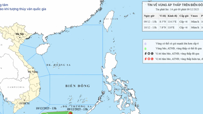
Tonight, super typhoon Ragasa enters the East Sea
Reporting at the meeting, Mr. Mai Van Khiem, Director of the National Center for Meteorological and Hydrological Forecasting, stated that at 5 PM the storm was located at approximately 19.4 ° N; 121.7 ° E; intensity level 17, with gusts exceeding level 17.
“After 10 p.m. tonight, the storm will officially enter the East Sea and become storm number 9 in 2025,” said Mr. Khiem.
Mr. Khiem stated that analysis of satellite data showing cross-sections through the storm's center revealed that the convective cloud zone surrounding the storm was developing very strongly, with high cloud tops and temperatures ranging from -70 ° C to -80 ° C. The storm's center was clear, hot, with temperatures above 15 ° C (hot center).

Mr. Mai Van Khiem, Director of the National Center for Hydro-Meteorological Forecasting.
The greater the difference between the temperature of the cloud tops around the storm's center and the temperature of the eye of the storm, the stronger the storm. The storm cloud formation is developing and shows no sign of weakening below level 17 in the next six hours.
Continuing the analysis, Mr. Khiem said that in the North there is high continental pressure, dry air mass from the North can affect the storm structure.
Forecasts indicate a high probability that the typhoon will enter Guangdong, weaken over mainland China, and then move into the Gulf of Tonkin. The typhoon is expected to enter the Gulf of Tonkin around the night of September 24th or the early morning of September 25th. At that time, its intensity may decrease to approximately level 9-10 on land and level 11-12 in the Gulf of Tonkin.
However, despite weakening, the storm's circulation remains very wide and dangerous, potentially causing strong winds, high waves, and heavy rain in the northern and north-central provinces, especially from September 25th and 26th.
"Based on the current storm forecast, the affected area is from Quang Ninh to Ha Tinh . The strongest winds will be from Quang Ninh to Thanh Hoa (coastal winds of force 7-9, gusts of 10-12, storm center winds of force 9-11, gusts of 14, further inland winds of force 6-7, gusts of 9-10). The period of strong winds will last from the morning of September 25th to the night of September 25th."
"The heaviest rainfall will be concentrated in the Northern region, Thanh Hoa - Ha Tinh with 70-150 mm of rain. The heaviest rainfall will be concentrated in Thai Nguyen, southern Tuyen Quang, Lao Cai , Phu Tho, and the Northern delta region with 150-250 mm of rain, and locally over 450 mm," Mr. Khiem said.
According to the Department of Dike Management and Disaster Prevention and Control, as of 4 PM today, they have notified, counted, and guided 54,058 vehicles/215,743 workers. All vehicles have received warning information, and none are located in the storm's affected area.
According to a report by the Ministry of Construction, the port area from Quang Ninh to Khanh Hoa has 874 vessels in operation, including 382 seagoing vessels and 492 inland waterway vessels. The provinces and cities from Quang Ninh to Hue have 161,354 hectares of aquaculture farms, 31,812 cages and rafts, and 3,875 aquaculture watchtowers. Over 800,000 hectares of rice have been planted in the Northern region, currently in the heading and ripening stages; nearly 130,000 hectares in the North Central region remain unharvested.
The strongest storm in history in the East Sea
Concluding the meeting, Deputy Minister of Agriculture and Environment Nguyen Hoang Hiep stated that flood and storm prevention efforts are now professionally organized, therefore we must have a firm grasp of the situation to develop more comprehensive and effective solutions.
"At this point, it can be confirmed that Typhoon No. 9, upon entering the East Sea, will be the strongest typhoon in the world in 2025 according to current measurements. This is also the strongest typhoon ever recorded in history in the East Sea region," Mr. Hiep emphasized.

The meeting was chaired by Deputy Minister of Agriculture and Environment Nguyen Hoang Hiep.
The Deputy Minister also stated that the forecast indicates the storm will officially enter the East Sea around 1-2 AM on September 23rd. According to the current scenario, upon entering the East Sea, due to some unfavorable factors, the storm may gradually decrease in intensity. The forecast predicts that from the early morning of September 25th, the storm will begin to affect the Gulf of Tonkin, then linger there, before making landfall around noon or early afternoon on September 25th. Upon entering the Gulf of Tonkin, the storm is likely to maintain a strength of level 9-10, with gusts of level 12-14; upon landfall, its intensity will be around level 8-9, with gusts of level 11-12.
However, he stated that this is only a forecast and its accuracy is not yet high. Therefore, the storm may become stronger or weaker, but it will certainly affect Vietnam, primarily at sea. Thus, the first priority is to strictly control the activities of ships and boats.
According to leaders of the Ministry of Agriculture and Environment, the Prime Minister has issued Directive 170, requesting the Border Guard, Construction, Transport, and Fisheries forces to coordinate control measures and prevent boats from going out to sea without being managed and counted starting today.
The second issue is aquaculture cages. Currently, the Northern and North Central regions and coastal areas have approximately 165,000 hectares of aquaculture cages, a very large number that needs to be strictly controlled.
The next concern is heavy rainfall and reservoir safety. According to current procedures, hydroelectric and irrigation reservoirs are at the end of the main flood season, with many nearly full. If the storm brings 150-450 mm of rain, operation will be very difficult. Therefore, it is necessary to closely monitor meteorological bulletins and use them as a basis for releasing floodwaters appropriately, avoiding a reactive situation like in some previous years.
Furthermore, this storm is very strong, has a wide circulation, and combined with cold air, it can cause extreme weather phenomena such as thunderstorms, tornadoes, lightning, and localized heavy rainfall. Accurate forecasting is difficult, therefore immediate warnings are needed for ships, especially in the Gulf of Tonkin.
Another important issue is the crop. Currently, there are over 810,000 hectares of rice, of which about 200,000 hectares have been harvested, and over 600,000 hectares are still green. If the typhoon hits, the damage will be enormous. Therefore, localities need to urgently harvest the ripe rice and proactively implement measures to protect crops and fruit trees.
Finally, regarding forecasting and communication, Mr. Hiep assessed this as a very strong storm requiring a different approach. He suggested that the Meteorological and Hydrological Center issue bulletins every three hours. At the same time, he emphasized the need for close coordination with the press and media to provide accurate and timely information to the public, avoiding complacency or excessive reporting that could cause panic.
"We need to step up the dissemination of information about the 112 hotline so that people know how to call when they need disaster assistance. This is a very important communication channel, but many people are not yet familiar with it. We will continue to assess the situation to advise the Government and the Prime Minister, and coordinate with localities to respond," Mr. Hiep said.
To respond to Typhoon No. 9, Major General Pham Hai Chau, Deputy Director of the Rescue and Relief Department (Ministry of National Defense), said that units in the areas expected to be affected by the typhoon have already prepared plans and strategies. More than 300,000 militia officers and soldiers, 8,000 vehicles and six aircraft are ready to respond when situations arise. The Ministry of National Defence has directed the Border Guard Command along the coast to call for, inform, and transmit information about the storm's trajectory. Currently, they have called, counted, and guided over 54,000 vessels and more than 200,000 fishermen to know the storm's path and seek safe shelter. |
Source plo.vn
Source: https://baophutho.vn/sieu-bao-ragasa-la-con-bao-manh-nhat-trong-lich-su-o-bien-dong-239967.htm


Comment (0)