
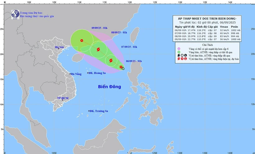
Forecast map of the tropical depression's trajectory and intensity at 2:00 a.m. on September 6.
The strongest wind near the center of the tropical depression is level 6 (39-49 km/h), gusting to level 8. Moving northwest at a speed of about 10 km/h.
Forecast of tropical depression/storm development in the next 24-48 hours, tropical depression/storm moving northwest, speed of about 10 km/hour and likely to strengthen into a storm.
The forecast location is about 18.7 degrees north latitude, 116.3 degrees east longitude, about 500 km east-northeast of the Paracel Islands. Wind force is level 8, gusting to level 10. The dangerous area is between latitude 16-20 degrees north; longitude 114.5-120 degrees east.
Disaster risk level: level 3, eastern sea area of the northern East Sea.
At 1:00 a.m. on September 8, the tropical depression/storm continued to move northwestward at a speed of about 15 km/h and intensified. The forecast location was at about 20.9 degrees north latitude - 113.8 degrees east longitude, in the northern sea area of the North East Sea. Strong winds at level 9, gusts at level 11. The dangerous area is between latitudes 17-22 degrees north; longitudes 112-118 degrees east. Disaster risk level: level 3, in the northern sea area of the North East Sea.
Storm warning for the next 48-72 hours, the storm moves west-northwest, about 15 km per hour.
In the northeastern part of the East Sea, there are strong winds of level 6, later increasing to level 7-8, gusting to level 10, waves 2-4m high, and rough seas. Ships operating in the danger zone are likely to be affected by storms, whirlwinds, strong winds, and large waves.
Source nhandan.vn
Source: https://baophutho.vn/tin-ap-thap-nhiet-doi-tren-bien-dong-co-kha-nang-manh-thanh-bao-239218.htm


![[Photo] General Secretary To Lam receives the Director of the Academy of Public Administration and National Economy under the President of the Russian Federation](/_next/image?url=https%3A%2F%2Fvphoto.vietnam.vn%2Fthumb%2F1200x675%2Fvietnam%2Fresource%2FIMAGE%2F2025%2F12%2F08%2F1765200203892_a1-bnd-0933-4198-jpg.webp&w=3840&q=75)


Comment (0)