

Specifically, due to the influence of storm circulation and cold air combined with East wind disturbances and terrain effects, from the night of October 22 to October 27, the area from Ha Tinh to Quang Ngai is likely to have widespread heavy rain. Total rainfall in: Ha Tinh to North Quang Tri and Quang Ngai is about 200-400 mm, locally over 500 mm; the area from South Quang Tri to Da Nang city is commonly 500-700 mm, locally over 900 mm. Warning of heavy rain over 200 mm/3 hours).
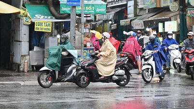
Forecast for the day and night of October 21, the area from Quang Tri to Da Nang, East of Quang Ngai to Lam Dong , the South will have scattered showers and thunderstorms of 15-30mm, locally more than 80mm.
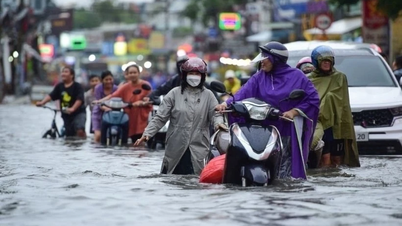
Heavy rains in the Central region are likely to last until the end of October 2025. There is a high risk of flash floods and landslides in mountainous areas, and flooding in low-lying and urban areas.
"Localities need to pay attention to safely operating hydroelectric and irrigation reservoirs before, during and after the storm, and prepare response plans for flood scenarios on rivers from Quang Tri to Quang Ngai that may reach alert level 3 and exceed alert level 3. Forecast level of natural disaster risk due to floods and inundation: level 3," Dr. Hoang Phuc Lam, Deputy Director of the National Center for Hydro-Meteorological Forecasting, noted.
According to the National Center for Hydro-Meteorological Forecasting, at 7:00 a.m. on October 21, the eye of the storm was at about 18.0 degrees North latitude; 112.6 degrees East longitude, about 130 km north of Hoang Sa special zone. The strongest wind near the eye of the storm was level 9-10 (75-102 km/h), gusting to level 12. Moving westward at a speed of about 20 km/h.
Forecast until 7am on October 22, the storm is in the sea west of Hoang Sa special zone, about 220km east-northeast of Da Nang city, with strong winds of level 9, gusts of level 11, moving in the West-Southwest direction at a speed of about 10-15km/h. The affected area is the sea west of the North East Sea (including Hoang Sa special zone). Disaster risk level 3.
Then, at 7:00 a.m. on October 23, the storm on the mainland from Da Nang city to Quang Ngai, with winds below level 6, gusting, moving southwest at a speed of about 10 km/h and likely to gradually weaken into a tropical depression and then a low pressure area.
Due to the impact of the storm, the North East Sea area (including Hoang Sa special zone) has strong winds of level 7-8; the area near the eye of the storm has strong winds of level 9-10, gusts of level 12; waves 3-5m high, the area near the eye of the storm is 5-7m high, the sea is very rough. The sea area from South Quang Tri to Quang Ngai (including Ly Son special zone) has strong winds of level 6, from the morning of October 22 increasing to level 7, the area near the eye of the storm has level 8, gusts of level 10, waves 3-5m high, the sea is rough.
All ships and boats operating in the above mentioned dangerous areas are susceptible to the impact of storms, whirlwinds, strong winds and large waves.
Source: https://baotintuc.vn/xa-hoi/anh-huong-bao-so-12-khu-vuc-trung-bo-mua-lon-tu-dem-2210-20251021092035686.htm


![[Photo] General Secretary To Lam receives the Director of the Academy of Public Administration and National Economy under the President of the Russian Federation](/_next/image?url=https%3A%2F%2Fvphoto.vietnam.vn%2Fthumb%2F1200x675%2Fvietnam%2Fresource%2FIMAGE%2F2025%2F12%2F08%2F1765200203892_a1-bnd-0933-4198-jpg.webp&w=3840&q=75)


Comment (0)